Vlasenica elevation
Vlasenica (Srpska), Bosnia and Herzegovina elevation is 660 meters and Vlasenica elevation in feet is 2165 ft above sea level [src 1]. Vlasenica is a seat of a second-order administrative division (feature code) with elevation that is 297 meters (974 ft) bigger than average city elevation in Bosnia and Herzegovina.
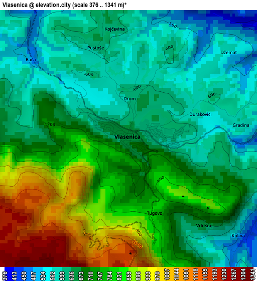
Below is the Elevation map of Vlasenica, which displays elevation range with different colors. Scale of the first map is from 376 to 1341 m (1234 to 4400 ft) with average elevation of 708.9 meters (=2326 ft) [note 1]
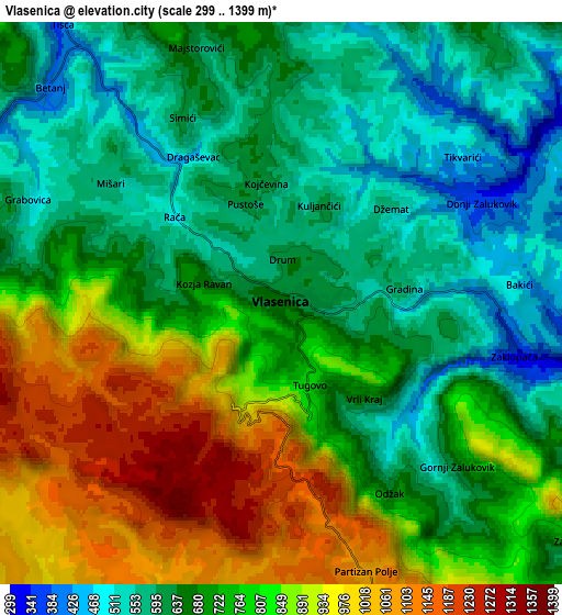
These maps also provides idea of topography and contour of this city, they are displayed at different zoom levels. More info about maps, scale and edge coordinates you can find below images.
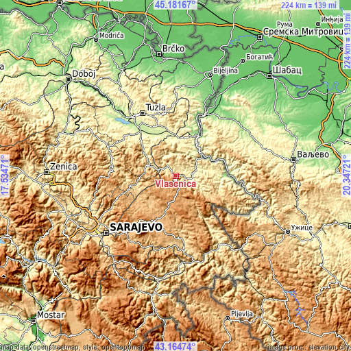
| \ | Map #1 | Map #2 | Topo.Map |
| Scale [m] | 376..1341 m | 299..1399 m | × |
| Scale [ft] | 1234..4400 ft | 981..4590 ft | × |
| Average | 708.9 m = 2326 ft | 733.5 m = 2406 ft | × |
| Width | 7.01 km = 4.4 mi | 14.02 km = 8.7 mi | 224.3 km = 139.4 mi |
| Height | 7.01 km = 4.4 mi | 14.02 km = 8.7 mi | 224.3 km = 139.4 mi |
| ↑Max Latitude | 44.213336° | 44.244825° | 45.18167° |
| Latitude at center | 44.18183° | 44.18183° | 44.18183° |
| ↓Min Latitude | 44.150307° | 44.118767° | 43.16474° |
| ← Min Longitude | 18.897015° | 18.853069° | 17.53471° |
| Longitude center | 18.94096° | 18.94096° | 18.94096° |
| →Max Longitude | 18.984905° | 19.028851° | 20.34721° |
Nearby cities:
Cities around Vlasenica sort by population:
• Sokolac elevation 876 m
29.3 km,  202°
202°
• Milići 426 m
12.1 km,  96°
96°
• Zvornik 163 m
26.1 km,  29°
29°
• Kladanj 572 m
20.4 km,  284°
284°
• Šekovići 340 m
14.7 km,  332°
332°
• Stupari 398 m
25.2 km,  305°
305°
• Han Pijesak 1086 m
11.2 km,  175°
175°
• Svojat 307 m
28.7 km, 325°
• Olovo 538 m
29.4 km,  258°
258°
• Srebrenica 371 m
29.6 km,  106°
106°
• Kalesija 293 m
28.6 km,  354°
354°
• Osmaci 287 m
24.5 km,  355°
355°
Multilingual:
 En español:
Vlasenica elevación 660 m.
 En France:
Vlasenica élévation 660 m.
 Auf Deutsch:
Vlasenica höhe über dem Meeresspiegel ist 660 m.

Sources and notes:
- [note 1] Map square and city borders are not equal. Map elevation data is calculated only from area inside that square.
- [src 1] Elevation data from geonames database provided with same terms of usage.
- [src 2] The elevation map of Vlasenica is generated using elevation data from NASA's 3 arcsec (90m) resolution SRTM data.
- [src 3] Base (background) map © OpenStreetMap contributors tiles are generated by Geofabrik and OpenTopoMap.
Copyright & License:
This Vlasenica Elevation Map is licensed under CC BY-SA. You may reuse any part from this page, if you give a proper credit by linking to this URL:
 More info on terms of use page.