Bungendore elevation
Bungendore (New South Wales, Queanbeyan-Palerang Regional), Australia elevation is 694 meters and Bungendore elevation in feet is 2277 ft above sea level [src 1]. Bungendore is a populated place (feature code) with elevation that is 581 meters (1906 ft) bigger than average city elevation in Australia.
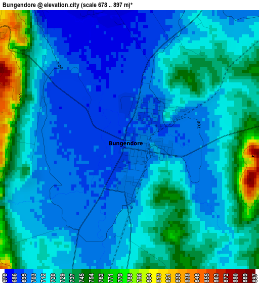
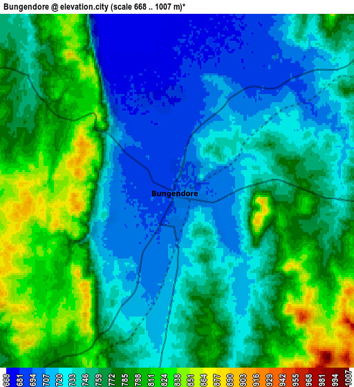
Below is the Elevation map of Bungendore, which displays elevation range with different colors. Scale of the first map is from 678 to 897 m (2224 to 2943 ft) with average elevation of 717.6 meters (=2354 ft) [note 1]
These maps also provides idea of topography and contour of this city, they are displayed at different zoom levels. More info about maps, scale and edge coordinates you can find below images.

| \ | Map #1 | Map #2 | Topo.Map |
| Scale [m] | 678..897 m | 668..1007 m | × |
| Scale [ft] | 2224..2943 ft | 2192..3304 ft | × |
| Average | 717.6 m = 2354 ft | 757.8 m = 2486 ft | × |
| Width | 7.98 km = 5 mi | 15.96 km = 9.9 mi | 255.4 km = 158.7 mi |
| Height | 7.98 km = 5 mi | 15.96 km = 9.9 mi | 255.4 km = 158.7 mi |
| ↑Max Latitude | -35.217926° | -35.182016° | -34.09738° |
| Latitude at center | -35.25382° | -35.25382° | -35.25382° |
| ↓Min Latitude | -35.289698° | -35.32556° | -36.394° |
| ← Min Longitude | 149.396125° | 149.352179° | 148.03382° |
| Longitude center | 149.44007° | 149.44007° | 149.44007° |
| →Max Longitude | 149.484015° | 149.527961° | 150.84632° |
Nearby cities:
Cities around Bungendore sort by population:
• Jerrabomberra elevation 618 m
26 km,  236°
236°
• Karabar 616 m
23.2 km,  234°
234°
• Queanbeyan 581 m
22 km, 239°
• Watson 592 m
26.2 km,  273°
273°
• Crestwood 616 m
22.8 km, 242°
• Queanbeyan East 587 m
20.4 km, 239°
• Queanbeyan West 592 m
24.2 km, 242°
• Hackett 611 m
25.1 km, 271°
• Sutton 614 m
19.8 km,  299°
299°
• Wamboin 796 m
9.7 km, 272°
• Carwoola 809 m
17.5 km,  217°
217°
• Bywong 753 m
14.1 km,  314°
314°
Multilingual:
 En español:
Bungendore elevación 694 m.
 En France:
Bungendore élévation 694 m.
 Auf Deutsch:
Bungendore höhe über dem Meeresspiegel ist 694 m.

Sources and notes:
- [note 1] Map square and city borders are not equal. Map elevation data is calculated only from area inside that square.
- [src 1] Elevation data from geonames database provided with same terms of usage.
- [src 2] The elevation map of Bungendore is generated using elevation data from NASA's 3 arcsec (90m) resolution SRTM data.
- [src 3] Base (background) map © OpenStreetMap contributors tiles are generated by Geofabrik and OpenTopoMap.
Copyright & License:
This Bungendore Elevation Map is licensed under CC BY-SA. You may reuse any part from this page, if you give a proper credit by linking to this URL:
 More info on terms of use page.