Queanbeyan West elevation
Queanbeyan West (New South Wales, Queanbeyan-Palerang Regional), Australia elevation is 592 meters and Queanbeyan West elevation in feet is 1942 ft above sea level [src 1]. Queanbeyan West is a section of populated place (feature code) with elevation that is 479 meters (1572 ft) bigger than average city elevation in Australia.
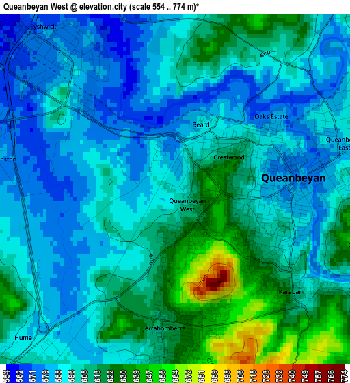
Below is the Elevation map of Queanbeyan West, which displays elevation range with different colors. Scale of the first map is from 554 to 774 m (1818 to 2539 ft) with average elevation of 600.3 meters (=1969 ft) [note 1]
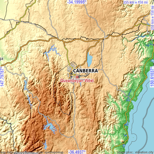
These maps also provides idea of topography and contour of this city, they are displayed at different zoom levels. More info about maps, scale and edge coordinates you can find below images.
| \ | Map #1 | Topo.Map |
| Scale [m] | 554..774 m | × |
| Scale [ft] | 1818..2539 ft | × |
| Average | 600.3 m = 1969 ft | × |
| Width | 7.97 km = 5 mi | 255 km = 158.4 mi |
| Height | 7.97 km = 5 mi | 255 km = 158.4 mi |
| ↑Max Latitude | -35.319121° | -34.19995° |
| Latitude at center | -35.35497° | -35.35497° |
| ↓Min Latitude | -35.390803° | -36.4937° |
| ← Min Longitude | 149.160175° | 147.79787° |
| Longitude center | 149.20412° | 149.20412° |
| →Max Longitude | 149.248065° | 150.61037° |
Nearby cities:
Cities around Queanbeyan West sort by population:
• Jerrabomberra elevation 618 m
3.3 km,  182°
182°
• Karabar 616 m
3.5 km,  131°
131°
• Queanbeyan 581 m
2.5 km,  89°
89°
• Narrabundah 583 m
5.4 km,  293°
293°
• Griffith 584 m
6.9 km,  298°
298°
• Crestwood 616 m
1.4 km,  59°
59°
• Kingston 562 m
6.8 km,  310°
310°
• Queanbeyan East 587 m
3.9 km,  75°
75°
• Red Hill 638 m
8.4 km, 292°
• Isaacs 686 m
8.2 km,  259°
259°
• Barton 554 m
8 km, 314°
• Forrest 583 m
8.2 km, 302°
Multilingual:
 En español:
Queanbeyan West elevación 592 m.
 En France:
Queanbeyan West élévation 592 m.
 Auf Deutsch:
Queanbeyan West höhe über dem Meeresspiegel ist 592 m.

Sources and notes:
- [note 1] Map square and city borders are not equal. Map elevation data is calculated only from area inside that square.
- [src 1] Elevation data from geonames database provided with same terms of usage.
- [src 2] The elevation map of Queanbeyan West is generated using elevation data from NASA's 3 arcsec (90m) resolution SRTM data.
- [src 3] Base (background) map © OpenStreetMap contributors tiles are generated by Geofabrik and OpenTopoMap.
Copyright & License:
This Queanbeyan West Elevation Map is licensed under CC BY-SA. You may reuse any part from this page, if you give a proper credit by linking to this URL:
 More info on terms of use page.