Goulburn elevation
Goulburn (New South Wales, Goulburn Mulwaree), Australia elevation is 642 meters and Goulburn elevation in feet is 2106 ft above sea level [src 1]. Goulburn is a populated place (feature code) with elevation that is 529 meters (1736 ft) bigger than average city elevation in Australia.
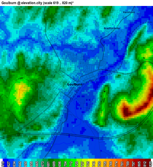
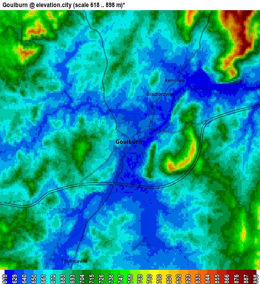
Below is the Elevation map of Goulburn, which displays elevation range with different colors. Scale of the first map is from 619 to 820 m (2031 to 2690 ft) with average elevation of 663.4 meters (=2177 ft) [note 1]
These maps also provides idea of topography and contour of this city, they are displayed at different zoom levels. More info about maps, scale and edge coordinates you can find below images.
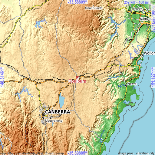
| \ | Map #1 | Map #2 | Topo.Map |
| Scale [m] | 619..820 m | 618..898 m | × |
| Scale [ft] | 2031..2690 ft | 2028..2946 ft | × |
| Average | 663.4 m = 2177 ft | 678.8 m = 2227 ft | × |
| Width | 8.03 km = 5 mi | 16.06 km = 10 mi | 256.9 km = 159.6 mi |
| Height | 8.03 km = 5 mi | 16.06 km = 10 mi | 256.9 km = 159.6 mi |
| ↑Max Latitude | -34.715435° | -34.679305° | -33.58809° |
| Latitude at center | -34.75155° | -34.75155° | -34.75155° |
| ↓Min Latitude | -34.787649° | -34.823732° | -35.89885° |
| ← Min Longitude | 149.676915° | 149.632969° | 148.31461° |
| Longitude center | 149.72086° | 149.72086° | 149.72086° |
| →Max Longitude | 149.764805° | 149.808751° | 151.12711° |
Nearby cities:
Cities around Goulburn sort by population:
• Moss Vale elevation 678 m
63.4 km,  69°
69°
• Forde 644 m
69.9 km,  228°
228°
• Bungendore 694 m
61.4 km,  204°
204°
• Murrumbateman 573 m
67.6 km,  248°
248°
• Bundanoon 679 m
53.6 km,  78°
78°
• Burradoo 680 m
68.7 km, 66°
• Crookwell 896 m
39.7 km,  324°
324°
• Sutton 614 m
63 km,  222°
222°
• Wamboin 796 m
65.8 km,  212°
212°
• Bywong 753 m
58.2 km, 217°
• Marulan 642 m
26.8 km, 79°
• Gundaroo 578 m
53.2 km, 233°
Multilingual:
 En español:
Goulburn elevación 642 m.
 En France:
Goulburn élévation 642 m.
 Auf Deutsch:
Goulburn höhe über dem Meeresspiegel ist 642 m.

Sources and notes:
- [note 1] Map square and city borders are not equal. Map elevation data is calculated only from area inside that square.
- [src 1] Elevation data from geonames database provided with same terms of usage.
- [src 2] The elevation map of Goulburn is generated using elevation data from NASA's 3 arcsec (90m) resolution SRTM data.
- [src 3] Base (background) map © OpenStreetMap contributors tiles are generated by Geofabrik and OpenTopoMap.
Copyright & License:
This Goulburn Elevation Map is licensed under CC BY-SA. You may reuse any part from this page, if you give a proper credit by linking to this URL:
 More info on terms of use page.