Lang Lang elevation
Lang Lang (Victoria, Cardinia), Australia elevation is 18 meters and Lang Lang elevation in feet is 59 ft above sea level [src 1]. Lang Lang is a section of populated place (feature code) with elevation that is 95 meters (312 ft) smaller than average city elevation in Australia.
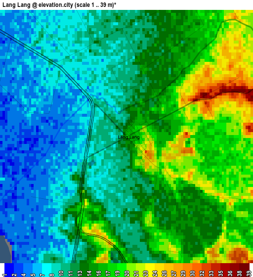
Below is the Elevation map of Lang Lang, which displays elevation range with different colors. Scale of the first map is from 1 to 39 m (3 to 128 ft) with average elevation of 13.1 meters (=43 ft) [note 1]
These maps also provides idea of topography and contour of this city, they are displayed at different zoom levels. More info about maps, scale and edge coordinates you can find below images.
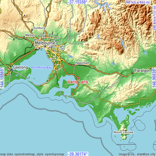
| \ | Map #1 | Topo.Map |
| Scale [m] | 1..39 m | × |
| Scale [ft] | 3..128 ft | × |
| Average | 13.1 m = 43 ft | × |
| Width | 7.67 km = 4.8 mi | 245.5 km = 152.5 mi |
| Height | 7.67 km = 4.8 mi | 245.5 km = 152.5 mi |
| ↑Max Latitude | -38.231538° | -37.15358° |
| Latitude at center | -38.26605° | -38.26605° |
| ↓Min Latitude | -38.300545° | -39.36174° |
| ← Min Longitude | 145.518155° | 144.15585° |
| Longitude center | 145.5621° | 145.5621° |
| →Max Longitude | 145.606045° | 146.96835° |
Nearby cities:
Cities around Lang Lang sort by population:
• Pakenham elevation 44 m
23.1 km,  340°
340°
• Clyde North 44 m
26 km,  309°
309°
• Officer 45 m
26.6 km,  329°
329°
• Koo-Wee-Rup 8 m
9.7 km,  319°
319°
• Bunyip 47 m
23 km,  35°
35°
• Clyde 37 m
24.8 km, 306°
• Longwarry 45 m
24.8 km,  46°
46°
• Garfield 50 m
21.9 km,  26°
26°
• Devon Meadows 35 m
25.4 km,  295°
295°
• Tooradin 6 m
16.6 km,  290°
290°
• Nyora 122 m
12.2 km,  127°
127°
• Blind Bight 13 m
20.4 km, 286°
Multilingual:
 En español:
Lang Lang elevación 18 m.
 En France:
Lang Lang élévation 18 m.
 Auf Deutsch:
Lang Lang höhe über dem Meeresspiegel ist 18 m.

Sources and notes:
- [note 1] Map square and city borders are not equal. Map elevation data is calculated only from area inside that square.
- [src 1] Elevation data from geonames database provided with same terms of usage.
- [src 2] The elevation map of Lang Lang is generated using elevation data from NASA's 3 arcsec (90m) resolution SRTM data.
- [src 3] Base (background) map © OpenStreetMap contributors tiles are generated by Geofabrik and OpenTopoMap.
Copyright & License:
This Lang Lang Elevation Map is licensed under CC BY-SA. You may reuse any part from this page, if you give a proper credit by linking to this URL:
 More info on terms of use page.