Pakenham elevation
Pakenham (Victoria, Cardinia), Australia elevation is 44 meters and Pakenham elevation in feet is 144 ft above sea level [src 1]. Pakenham is a section of populated place (feature code) with elevation that is 69 meters (226 ft) smaller than average city elevation in Australia.
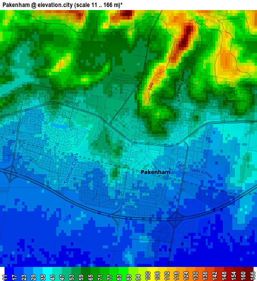
Below is the Elevation map of Pakenham, which displays elevation range with different colors. Scale of the first map is from 11 to 166 m (36 to 545 ft) with average elevation of 47 meters (=154 ft) [note 1]
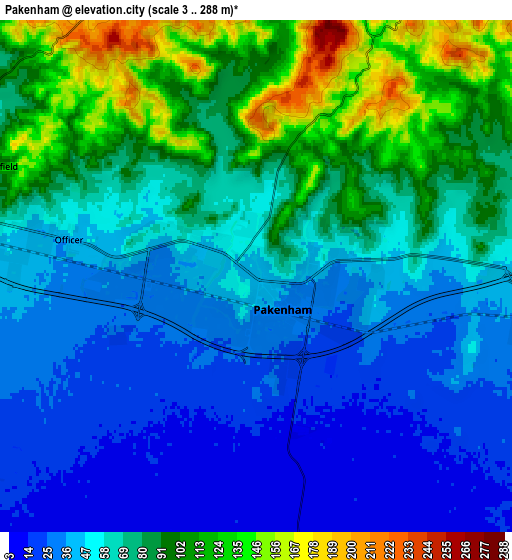
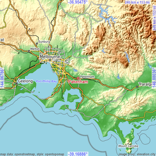
These maps also provides idea of topography and contour of this city, they are displayed at different zoom levels. More info about maps, scale and edge coordinates you can find below images.
| \ | Map #1 | Map #2 | Topo.Map |
| Scale [m] | 11..166 m | 3..288 m | × |
| Scale [ft] | 36..545 ft | 10..945 ft | × |
| Average | 47 m = 154 ft | 65.2 m = 214 ft | × |
| Width | 7.69 km = 4.8 mi | 15.39 km = 9.6 mi | 246.2 km = 153 mi |
| Height | 7.69 km = 4.8 mi | 15.39 km = 9.6 mi | 246.2 km = 153 mi |
| ↑Max Latitude | -38.035576° | -38.000955° | -36.95475° |
| Latitude at center | -38.07018° | -38.07018° | -38.07018° |
| ↓Min Latitude | -38.104768° | -38.13934° | -39.16886° |
| ← Min Longitude | 145.430165° | 145.386219° | 144.06786° |
| Longitude center | 145.47411° | 145.47411° | 145.47411° |
| →Max Longitude | 145.518055° | 145.562001° | 146.88036° |
Nearby cities:
Cities around Pakenham sort by population:
• Berwick elevation 90 m
11.6 km,  290°
290°
• Cranbourne North 41 m
15.4 km,  266°
266°
• Clyde North 44 m
13.4 km,  247°
247°
• Officer 45 m
5.8 km,  282°
282°
• Beaconsfield 58 m
9.7 km, 283°
• Emerald 321 m
15.7 km,  349°
349°
• Cockatoo 215 m
14.9 km,  6°
6°
• Koo-Wee-Rup 8 m
14.4 km,  174°
174°
• Beaconsfield Upper 208 m
9.9 km,  328°
328°
• Gembrook 322 m
14.8 km,  28°
28°
• Clyde 37 m
14.2 km,  240°
240°
• Pakenham Upper 196 m
7 km, 32°
Multilingual:
 En español:
Pakenham elevación 44 m.
 En France:
Pakenham élévation 44 m.


Sources and notes:
- [note 1] Map square and city borders are not equal. Map elevation data is calculated only from area inside that square.
- [src 1] Elevation data from geonames database provided with same terms of usage.
- [src 2] The elevation map of Pakenham is generated using elevation data from NASA's 3 arcsec (90m) resolution SRTM data.
- [src 3] Base (background) map © OpenStreetMap contributors tiles are generated by Geofabrik and OpenTopoMap.
Copyright & License:
This Pakenham Elevation Map is licensed under CC BY-SA. You may reuse any part from this page, if you give a proper credit by linking to this URL:
 More info on terms of use page.