Clyde elevation
Clyde (Victoria, Casey), Australia elevation is 37 meters and Clyde elevation in feet is 121 ft above sea level [src 1]. Clyde is a section of populated place (feature code) with elevation that is 76 meters (249 ft) smaller than average city elevation in Australia.
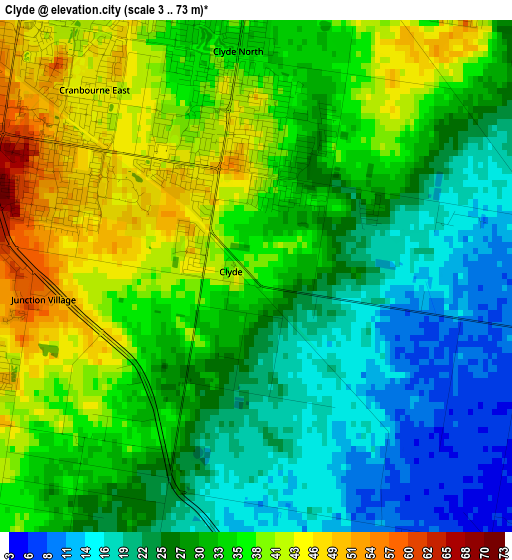
Below is the Elevation map of Clyde, which displays elevation range with different colors. Scale of the first map is from 3 to 73 m (10 to 240 ft) with average elevation of 30.8 meters (=101 ft) [note 1]
These maps also provides idea of topography and contour of this city, they are displayed at different zoom levels. More info about maps, scale and edge coordinates you can find below images.
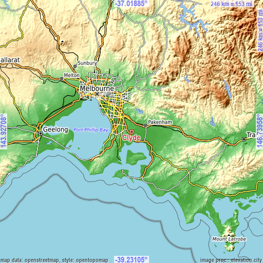
| \ | Map #1 | Topo.Map |
| Scale [m] | 3..73 m | × |
| Scale [ft] | 10..240 ft | × |
| Average | 30.8 m = 101 ft | × |
| Width | 7.69 km = 4.8 mi | 246 km = 152.9 mi |
| Height | 7.69 km = 4.8 mi | 246 km = 152.9 mi |
| ↑Max Latitude | -38.098755° | -37.01885° |
| Latitude at center | -38.13333° | -38.13333° |
| ↓Min Latitude | -38.167888° | -39.23105° |
| ← Min Longitude | 145.289385° | 143.92708° |
| Longitude center | 145.33333° | 145.33333° |
| →Max Longitude | 145.377275° | 146.73958° |
Nearby cities:
Cities around Clyde sort by population:
• Cranbourne North elevation 41 m
6.9 km,  333°
333°
• Cranbourne 67 m
4.9 km,  296°
296°
• Cranbourne East 50 m
3.7 km, 303°
• Cranbourne West 40 m
7.1 km,  305°
305°
• Clyde North 44 m
1.9 km,  0°
0°
• Beaconsfield 58 m
9.7 km,  17°
17°
• Botanic Ridge 74 m
5.7 km,  263°
263°
• Cranbourne South 84 m
8.2 km,  268°
268°
• Devon Meadows 35 m
4.7 km,  218°
218°
• Tooradin 6 m
10 km,  154°
154°
• Blind Bight 13 m
9 km,  177°
177°
• Junction Village 56 m
3.2 km, 263°
Multilingual:
 En español:
Clyde elevación 37 m.
 En France:
Clyde élévation 37 m.


Sources and notes:
- [note 1] Map square and city borders are not equal. Map elevation data is calculated only from area inside that square.
- [src 1] Elevation data from geonames database provided with same terms of usage.
- [src 2] The elevation map of Clyde is generated using elevation data from NASA's 3 arcsec (90m) resolution SRTM data.
- [src 3] Base (background) map © OpenStreetMap contributors tiles are generated by Geofabrik and OpenTopoMap.
Copyright & License:
This Clyde Elevation Map is licensed under CC BY-SA. You may reuse any part from this page, if you give a proper credit by linking to this URL:
 More info on terms of use page.