Merriwa elevation
Merriwa (New South Wales, Upper Hunter Shire), Australia elevation is 253 meters and Merriwa elevation in feet is 830 ft above sea level [src 1]. Merriwa is a populated place (feature code) with elevation that is 140 meters (459 ft) bigger than average city elevation in Australia.
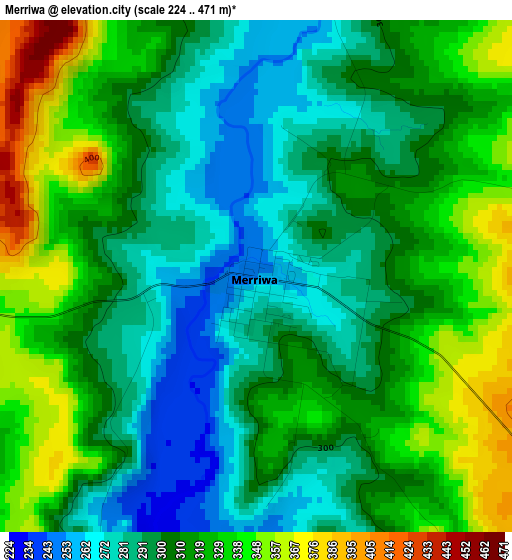
Below is the Elevation map of Merriwa, which displays elevation range with different colors. Scale of the first map is from 224 to 471 m (735 to 1545 ft) with average elevation of 309.2 meters (=1014 ft) [note 1]
These maps also provides idea of topography and contour of this city, they are displayed at different zoom levels. More info about maps, scale and edge coordinates you can find below images.
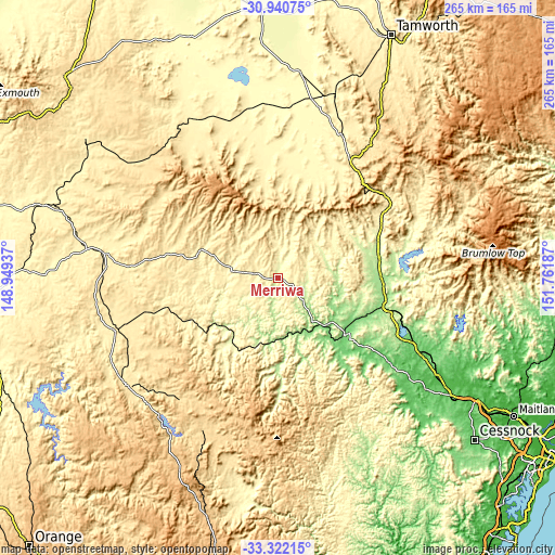
| \ | Map #1 | Topo.Map |
| Scale [m] | 224..471 m | × |
| Scale [ft] | 735..1545 ft | × |
| Average | 309.2 m = 1014 ft | × |
| Width | 8.27 km = 5.1 mi | 264.8 km = 164.5 mi |
| Height | 8.27 km = 5.1 mi | 264.8 km = 164.5 mi |
| ↑Max Latitude | -32.102001° | -30.94075° |
| Latitude at center | -32.13922° | -32.13922° |
| ↓Min Latitude | -32.176423° | -33.32215° |
| ← Min Longitude | 150.311675° | 148.94937° |
| Longitude center | 150.35562° | 150.35562° |
| →Max Longitude | 150.399565° | 151.76187° |
Nearby cities:
Cities around Merriwa sort by population:
• Muswellbrook elevation 164 m
52.1 km,  105°
105°
• Mudgee 459 m
88.1 km,  234°
234°
• Scone 216 m
49.4 km,  78°
78°
• Singleton Heights 76 m
87.9 km,  120°
120°
• Quirindi 403 m
76.6 km,  23°
23°
• Hunterview 50 m
89.3 km, 120°
• Gulgong 471 m
81.3 km,  252°
252°
• Aberdeen 179 m
50.4 km,  93°
93°
• Denman 108 m
41.8 km,  131°
131°
• Kandos 628 m
87.8 km,  204°
204°
• Coolah 492 m
69.6 km,  299°
299°
• Murrurundi 469 m
61.6 km,  47°
47°
Multilingual:
 En español:
Merriwa elevación 253 m.
 En France:
Merriwa élévation 253 m.


Sources and notes:
- [note 1] Map square and city borders are not equal. Map elevation data is calculated only from area inside that square.
- [src 1] Elevation data from geonames database provided with same terms of usage.
- [src 2] The elevation map of Merriwa is generated using elevation data from NASA's 3 arcsec (90m) resolution SRTM data.
- [src 3] Base (background) map © OpenStreetMap contributors tiles are generated by Geofabrik and OpenTopoMap.
Copyright & License:
This Merriwa Elevation Map is licensed under CC BY-SA. You may reuse any part from this page, if you give a proper credit by linking to this URL:
 More info on terms of use page.