Kandos elevation
Kandos (New South Wales, Mid-Western Regional), Australia elevation is 628 meters and Kandos elevation in feet is 2060 ft above sea level [src 1]. Kandos is a populated place (feature code) with elevation that is 515 meters (1690 ft) bigger than average city elevation in Australia.
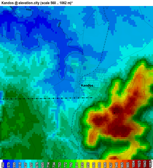
Below is the Elevation map of Kandos, which displays elevation range with different colors. Scale of the first map is from 560 to 1062 m (1837 to 3484 ft) with average elevation of 693.5 meters (=2275 ft) [note 1]
These maps also provides idea of topography and contour of this city, they are displayed at different zoom levels. More info about maps, scale and edge coordinates you can find below images.
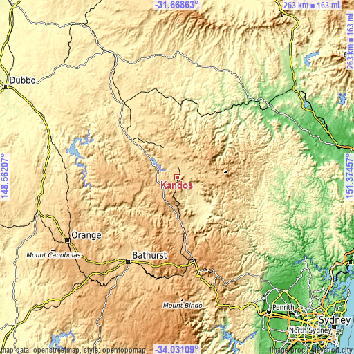
| \ | Map #1 | Topo.Map |
| Scale [m] | 560..1062 m | × |
| Scale [ft] | 1837..3484 ft | × |
| Average | 693.5 m = 2275 ft | × |
| Width | 8.21 km = 5.1 mi | 262.7 km = 163.2 mi |
| Height | 8.21 km = 5.1 mi | 262.7 km = 163.2 mi |
| ↑Max Latitude | -32.820797° | -31.66863° |
| Latitude at center | -32.85772° | -32.85772° |
| ↓Min Latitude | -32.894627° | -34.03109° |
| ← Min Longitude | 149.924375° | 148.56207° |
| Longitude center | 149.96832° | 149.96832° |
| →Max Longitude | 150.012265° | 151.37457° |
Nearby cities:
Cities around Kandos sort by population:
• Bathurst elevation 819 m
71.9 km,  210°
210°
• Mudgee 459 m
46.1 km,  309°
309°
• Kelso 649 m
71 km, 208°
• Lithgow 916 m
71.7 km,  166°
166°
• Gulgong 471 m
68.6 km,  323°
323°
• Portland 941 m
55.5 km,  178°
178°
• Eglinton 657 m
69.9 km, 214°
• Llanarth 681 m
71.4 km, 212°
• Bowenfels 915 m
71.3 km, 167°
• Wallerawang 897 m
62.2 km, 171°
• Raglan 764 m
68.2 km,  204°
204°
• Abercrombie 669 m
70.9 km, 213°
Multilingual:
 En español:
Kandos elevación 628 m.
 En France:
Kandos élévation 628 m.


Sources and notes:
- [note 1] Map square and city borders are not equal. Map elevation data is calculated only from area inside that square.
- [src 1] Elevation data from geonames database provided with same terms of usage.
- [src 2] The elevation map of Kandos is generated using elevation data from NASA's 3 arcsec (90m) resolution SRTM data.
- [src 3] Base (background) map © OpenStreetMap contributors tiles are generated by Geofabrik and OpenTopoMap.
Copyright & License:
This Kandos Elevation Map is licensed under CC BY-SA. You may reuse any part from this page, if you give a proper credit by linking to this URL:
 More info on terms of use page.