Mudgee elevation
Mudgee (New South Wales, Mid-Western Regional), Australia elevation is 459 meters and Mudgee elevation in feet is 1506 ft above sea level [src 1]. Mudgee is a populated place (feature code) with elevation that is 346 meters (1135 ft) bigger than average city elevation in Australia.
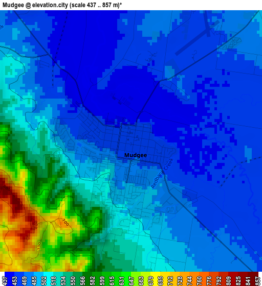
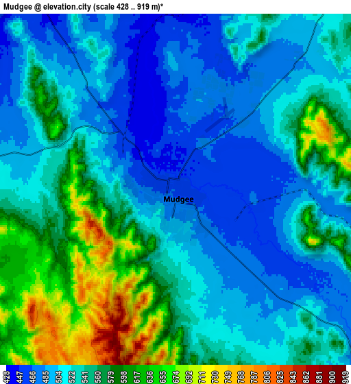
Below is the Elevation map of Mudgee, which displays elevation range with different colors. Scale of the first map is from 437 to 857 m (1434 to 2812 ft) with average elevation of 500.5 meters (=1642 ft) [note 1]
These maps also provides idea of topography and contour of this city, they are displayed at different zoom levels. More info about maps, scale and edge coordinates you can find below images.
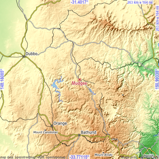
| \ | Map #1 | Map #2 | Topo.Map |
| Scale [m] | 437..857 m | 428..919 m | × |
| Scale [ft] | 1434..2812 ft | 1404..3015 ft | × |
| Average | 500.5 m = 1642 ft | 539.3 m = 1769 ft | × |
| Width | 8.23 km = 5.1 mi | 16.47 km = 10.2 mi | 263.5 km = 163.7 mi |
| Height | 8.23 km = 5.1 mi | 16.47 km = 10.2 mi | 263.5 km = 163.7 mi |
| ↑Max Latitude | -32.557228° | -32.520181° | -31.4017° |
| Latitude at center | -32.59426° | -32.59426° | -32.59426° |
| ↓Min Latitude | -32.631277° | -32.668278° | -33.77115° |
| ← Min Longitude | 149.543155° | 149.499209° | 148.18085° |
| Longitude center | 149.5871° | 149.5871° | 149.5871° |
| →Max Longitude | 149.631045° | 149.674991° | 150.99335° |
Nearby cities:
Cities around Mudgee sort by population:
• Orange elevation 868 m
89.1 km,  210°
210°
• Wellington 304 m
60.3 km,  274°
274°
• Windradyne 708 m
90.3 km,  182°
182°
• Molong 532 m
86.9 km,  230°
230°
• Gulgong 471 m
26.3 km,  348°
348°
• Eglinton 657 m
87.1 km, 182°
• Llanarth 681 m
89.3 km, 182°
• Merriwa 253 m
88.1 km,  54°
54°
• Kandos 628 m
46.1 km,  129°
129°
• Dunedoo 384 m
67 km,  343°
343°
• Coolah 492 m
86.1 km,  8°
8°
• Abercrombie 669 m
88.4 km, 182°
Multilingual:
 En español:
Mudgee elevación 459 m.
 En France:
Mudgee élévation 459 m.


Sources and notes:
- [note 1] Map square and city borders are not equal. Map elevation data is calculated only from area inside that square.
- [src 1] Elevation data from geonames database provided with same terms of usage.
- [src 2] The elevation map of Mudgee is generated using elevation data from NASA's 3 arcsec (90m) resolution SRTM data.
- [src 3] Base (background) map © OpenStreetMap contributors tiles are generated by Geofabrik and OpenTopoMap.
Copyright & License:
This Mudgee Elevation Map is licensed under CC BY-SA. You may reuse any part from this page, if you give a proper credit by linking to this URL:
 More info on terms of use page.