Itter elevation
Itter (Tyrol, Politischer Bezirk Kitzbühel), Austria elevation is 613 meters and Itter elevation in feet is 2011 ft above sea level [src 1]. Itter is a seat of a third-order administrative division (feature code) with elevation that is 104 meters (341 ft) bigger than average city elevation in Austria.
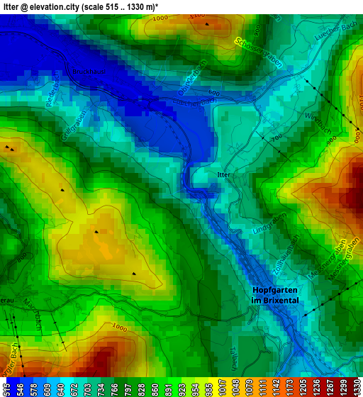
Below is the Elevation map of Itter, which displays elevation range with different colors. Scale of the first map is from 515 to 1330 m (1690 to 4364 ft) with average elevation of 802.8 meters (=2634 ft) [note 1]
These maps also provides idea of topography and contour of this city, they are displayed at different zoom levels. More info about maps, scale and edge coordinates you can find below images.
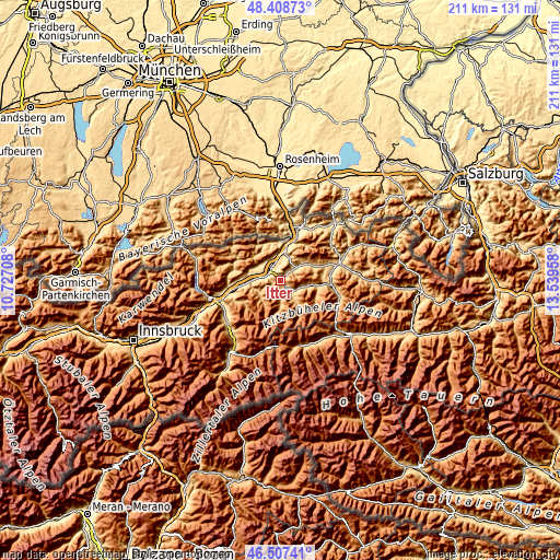
| \ | Map #1 | Topo.Map |
| Scale [m] | 515..1330 m | × |
| Scale [ft] | 1690..4364 ft | × |
| Average | 802.8 m = 2634 ft | × |
| Width | 6.61 km = 4.1 mi | 211.4 km = 131.4 mi |
| Height | 6.61 km = 4.1 mi | 211.4 km = 131.4 mi |
| ↑Max Latitude | 47.496369° | 48.40873° |
| Latitude at center | 47.46667° | 47.46667° |
| ↓Min Latitude | 47.436954° | 46.50741° |
| ← Min Longitude | 12.089385° | 10.72708° |
| Longitude center | 12.13333° | 12.13333° |
| →Max Longitude | 12.177275° | 13.53958° |
Nearby cities:
Cities around Itter sort by population:
• Wörgl elevation 506 m
5.9 km,  294°
294°
• Kirchbichl 529 m
6.3 km,  333°
333°
• Westendorf 782 m
7.2 km,  122°
122°
• Söll 691 m
6 km,  46°
46°
• Bad Häring 589 m
5 km,  347°
347°
• Hopfgarten im Brixental 610 m
2.6 km,  137°
137°
• Schwoich 571 m
8.8 km,  3°
3°
• Oberau 930 m
6.9 km,  247°
247°
• Angerberg 658 m
8.8 km,  299°
299°
• Niederbreitenbach 503 m
8.3 km, 333°
• Niederau 819 m
4.2 km,  243°
243°
• Angath 499 m
6.9 km,  311°
311°
Multilingual:
 En español:
Itter elevación 613 m.
 En France:
Itter élévation 613 m.


Sources and notes:
- [note 1] Map square and city borders are not equal. Map elevation data is calculated only from area inside that square.
- [src 1] Elevation data from geonames database provided with same terms of usage.
- [src 2] The elevation map of Itter is generated using elevation data from NASA's 3 arcsec (90m) resolution SRTM data.
- [src 3] Base (background) map © OpenStreetMap contributors tiles are generated by Geofabrik and OpenTopoMap.
Copyright & License:
This Itter Elevation Map is licensed under CC BY-SA. You may reuse any part from this page, if you give a proper credit by linking to this URL:
 More info on terms of use page.