Wörgl elevation
Wörgl (Tyrol, Politischer Bezirk Kufstein), Austria elevation is 506 meters and Wörgl elevation in feet is 1660 ft above sea level [src 1]. Wörgl is a seat of a third-order administrative division (feature code) with elevation that is 3 meters (10 ft) smaller than average city elevation in Austria.
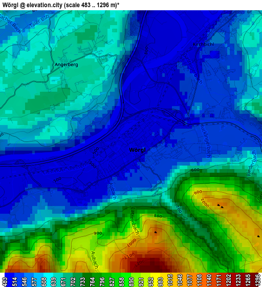
Below is the Elevation map of Wörgl, which displays elevation range with different colors. Scale of the first map is from 483 to 1296 m (1585 to 4252 ft) with average elevation of 657.5 meters (=2157 ft) [note 1]
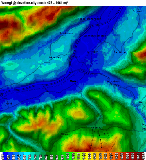
These maps also provides idea of topography and contour of this city, they are displayed at different zoom levels. More info about maps, scale and edge coordinates you can find below images.
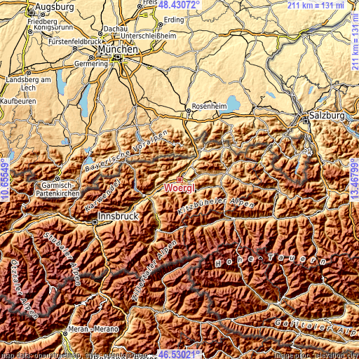
| \ | Map #1 | Map #2 | Topo.Map |
| Scale [m] | 483..1296 m | 475..1661 m | × |
| Scale [ft] | 1585..4252 ft | 1558..5449 ft | × |
| Average | 657.5 m = 2157 ft | 803.7 m = 2637 ft | × |
| Width | 6.6 km = 4.1 mi | 13.21 km = 8.2 mi | 211.3 km = 131.3 mi |
| Height | 6.6 km = 4.1 mi | 13.21 km = 8.2 mi | 211.3 km = 131.3 mi |
| ↑Max Latitude | 47.518747° | 47.548417° | 48.43072° |
| Latitude at center | 47.48906° | 47.48906° | 47.48906° |
| ↓Min Latitude | 47.459356° | 47.429636° | 46.53021° |
| ← Min Longitude | 12.017795° | 11.973849° | 10.65549° |
| Longitude center | 12.06174° | 12.06174° | 12.06174° |
| →Max Longitude | 12.105685° | 12.149631° | 13.46799° |
Nearby cities:
Cities around Wörgl sort by population:
• Kirchbichl elevation 529 m
4.1 km,  39°
39°
• Kundl 533 m
6.4 km,  247°
247°
• Bad Häring 589 m
4.9 km,  60°
60°
• Breitenbach am Inn 508 m
6.7 km,  259°
259°
• Oberau 930 m
5.2 km,  190°
190°
• Angerberg 658 m
2.9 km,  308°
308°
• Itter 613 m
5.9 km,  114°
114°
• Niederbreitenbach 503 m
5.2 km,  18°
18°
• Niederau 819 m
4.6 km,  159°
159°
• Angath 499 m
2.1 km,  7°
7°
• Mariastein 562 m
4.3 km,  353°
353°
• Langkampfen 498 m
7.3 km, 24°
Multilingual:
 En español:
Wörgl elevación 506 m.
 En France:
Wörgl élévation 506 m.


Sources and notes:
- [note 1] Map square and city borders are not equal. Map elevation data is calculated only from area inside that square.
- [src 1] Elevation data from geonames database provided with same terms of usage.
- [src 2] The elevation map of Wörgl is generated using elevation data from NASA's 3 arcsec (90m) resolution SRTM data.
- [src 3] Base (background) map © OpenStreetMap contributors tiles are generated by Geofabrik and OpenTopoMap.
Copyright & License:
This Wörgl Elevation Map is licensed under CC BY-SA. You may reuse any part from this page, if you give a proper credit by linking to this URL:
 More info on terms of use page.