Kundl elevation
Kundl (Tyrol, Politischer Bezirk Kufstein), Austria elevation is 533 meters and Kundl elevation in feet is 1749 ft above sea level [src 1]. Kundl is a seat of a third-order administrative division (feature code) with elevation that is 24 meters (79 ft) bigger than average city elevation in Austria.
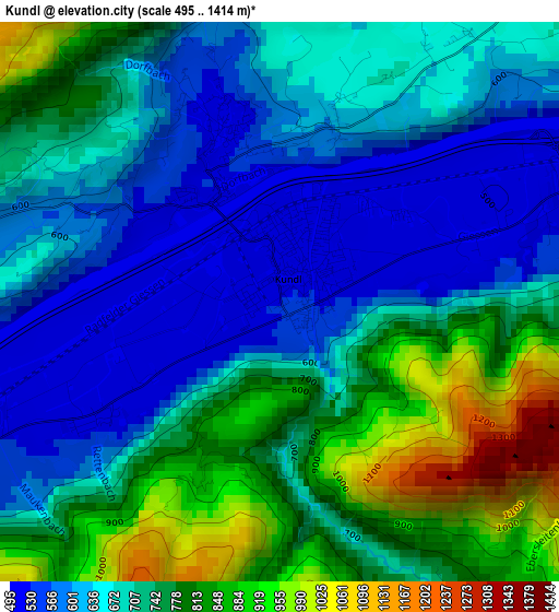
Below is the Elevation map of Kundl, which displays elevation range with different colors. Scale of the first map is from 495 to 1414 m (1624 to 4639 ft) with average elevation of 708.5 meters (=2324 ft) [note 1]
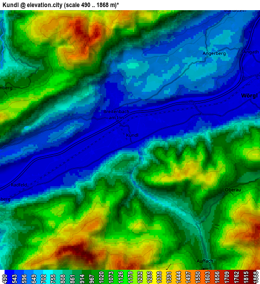
These maps also provides idea of topography and contour of this city, they are displayed at different zoom levels. More info about maps, scale and edge coordinates you can find below images.
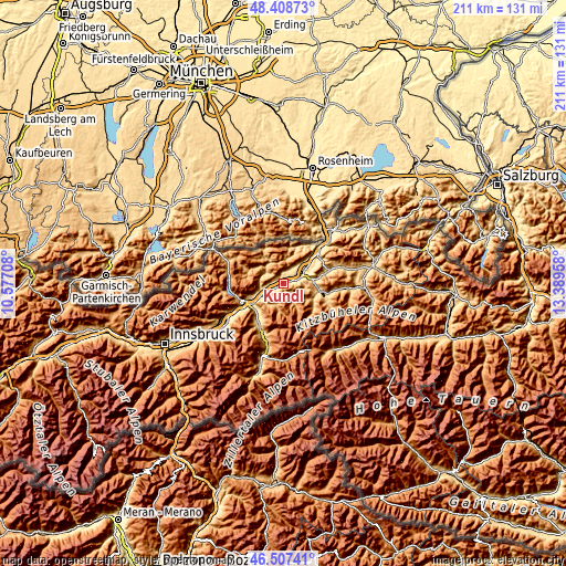
| \ | Map #1 | Map #2 | Topo.Map |
| Scale [m] | 495..1414 m | 490..1868 m | × |
| Scale [ft] | 1624..4639 ft | 1608..6129 ft | × |
| Average | 708.5 m = 2324 ft | 897.3 m = 2944 ft | × |
| Width | 6.61 km = 4.1 mi | 13.21 km = 8.2 mi | 211.4 km = 131.4 mi |
| Height | 6.61 km = 4.1 mi | 13.21 km = 8.2 mi | 211.4 km = 131.4 mi |
| ↑Max Latitude | 47.496369° | 47.526052° | 48.40873° |
| Latitude at center | 47.46667° | 47.46667° | 47.46667° |
| ↓Min Latitude | 47.436954° | 47.407221° | 46.50741° |
| ← Min Longitude | 11.939385° | 11.895439° | 10.57708° |
| Longitude center | 11.98333° | 11.98333° | 11.98333° |
| →Max Longitude | 12.027275° | 12.071221° | 13.38958° |
Nearby cities:
Cities around Kundl sort by population:
• Wörgl elevation 506 m
6.4 km,  67°
67°
• Voldöpp 519 m
7.9 km,  251°
251°
• Alpbach 971 m
8.1 km,  201°
201°
• Radfeld 512 m
5.6 km, 248°
• Breitenbach am Inn 508 m
1.5 km,  330°
330°
• Oberau 930 m
5.6 km,  117°
117°
• Angerberg 658 m
5.6 km,  39°
39°
• Brandenberg 918 m
7.2 km,  291°
291°
• Niederau 819 m
7.7 km,  103°
103°
• Angath 499 m
7.6 km,  53°
53°
• Rattenberg 524 m
7.4 km, 245°
• Wildschönau 898 m
7.9 km,  148°
148°
Multilingual:
 En español:
Kundl elevación 533 m.
 En France:
Kundl élévation 533 m.


Sources and notes:
- [note 1] Map square and city borders are not equal. Map elevation data is calculated only from area inside that square.
- [src 1] Elevation data from geonames database provided with same terms of usage.
- [src 2] The elevation map of Kundl is generated using elevation data from NASA's 3 arcsec (90m) resolution SRTM data.
- [src 3] Base (background) map © OpenStreetMap contributors tiles are generated by Geofabrik and OpenTopoMap.
Copyright & License:
This Kundl Elevation Map is licensed under CC BY-SA. You may reuse any part from this page, if you give a proper credit by linking to this URL:
 More info on terms of use page.