Hopfgarten im Brixental elevation
Hopfgarten im Brixental (Tyrol, Politischer Bezirk Kitzbühel), Austria elevation is 610 meters and Hopfgarten im Brixental elevation in feet is 2001 ft above sea level [src 1]. Hopfgarten im Brixental is a populated place (feature code) with elevation that is 101 meters (331 ft) bigger than average city elevation in Austria.
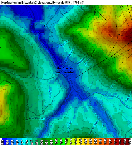
Below is the Elevation map of Hopfgarten im Brixental, which displays elevation range with different colors. Scale of the first map is from 549 to 1709 m (1801 to 5607 ft) with average elevation of 876.5 meters (=2876 ft) [note 1]
These maps also provides idea of topography and contour of this city, they are displayed at different zoom levels. More info about maps, scale and edge coordinates you can find below images.
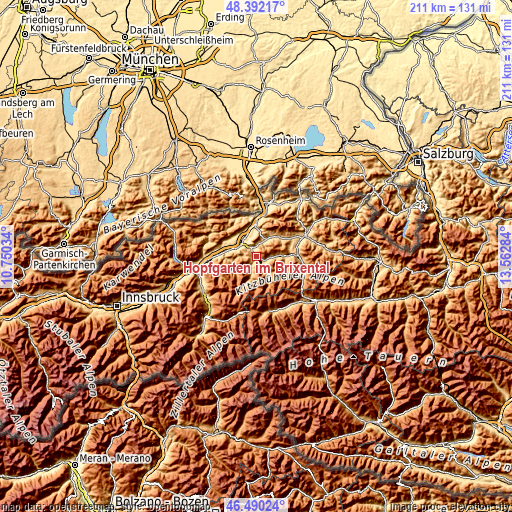
| \ | Map #1 | Topo.Map |
| Scale [m] | 549..1709 m | × |
| Scale [ft] | 1801..5607 ft | × |
| Average | 876.5 m = 2876 ft | × |
| Width | 6.61 km = 4.1 mi | 211.5 km = 131.4 mi |
| Height | 6.61 km = 4.1 mi | 211.5 km = 131.4 mi |
| ↑Max Latitude | 47.479509° | 48.39217° |
| Latitude at center | 47.4498° | 47.4498° |
| ↓Min Latitude | 47.420074° | 46.49024° |
| ← Min Longitude | 12.112645° | 10.75034° |
| Longitude center | 12.15659° | 12.15659° |
| →Max Longitude | 12.200535° | 13.56284° |
Nearby cities:
Cities around Hopfgarten im Brixental sort by population:
• Wörgl elevation 506 m
8.4 km,  301°
301°
• Kirchbichl 529 m
8.8 km,  328°
328°
• Westendorf 782 m
4.7 km,  114°
114°
• Söll 691 m
6.6 km,  24°
24°
• Bad Häring 589 m
7.3 km,  337°
337°
• Brixen im Thale 798 m
7 km,  89°
89°
• Oberau 930 m
8.1 km,  264°
264°
• Itter 613 m
2.6 km,  317°
317°
• Niederbreitenbach 503 m
10.8 km, 329°
• Niederau 819 m
5.5 km,  270°
270°
• Angath 499 m
9.4 km,  313°
313°
• Wildschönau 898 m
10.2 km,  241°
241°
Multilingual:
 En español:
Hopfgarten im Brixental elevación 610 m.
 En France:
Hopfgarten im Brixental élévation 610 m.
 Auf Deutsch:
Hopfgarten im Brixental höhe über dem Meeresspiegel ist 610 m.
 На русском:
Хопфгартен-им-Бриксенталь высота над уровнем моря 610 м
Sources and notes:
- [note 1] Map square and city borders are not equal. Map elevation data is calculated only from area inside that square.
- [src 1] Elevation data from geonames database provided with same terms of usage.
- [src 2] The elevation map of Hopfgarten im Brixental is generated using elevation data from NASA's 3 arcsec (90m) resolution SRTM data.
- [src 3] Base (background) map © OpenStreetMap contributors tiles are generated by Geofabrik and OpenTopoMap.
Copyright & License:
This Hopfgarten im Brixental Elevation Map is licensed under CC BY-SA. You may reuse any part from this page, if you give a proper credit by linking to this URL:
 More info on terms of use page.