Westendorf elevation
Westendorf (Tyrol, Politischer Bezirk Kitzbühel), Austria elevation is 782 meters and Westendorf elevation in feet is 2566 ft above sea level [src 1]. Westendorf is a seat of a third-order administrative division (feature code) with elevation that is 273 meters (896 ft) bigger than average city elevation in Austria.
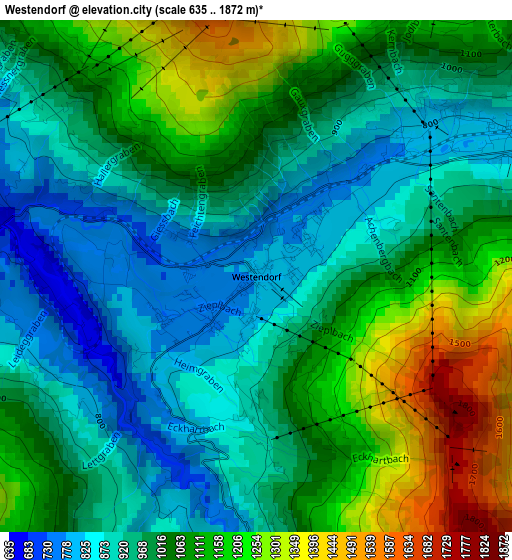
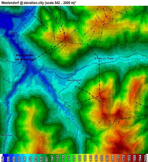
Below is the Elevation map of Westendorf, which displays elevation range with different colors. Scale of the first map is from 635 to 1872 m (2083 to 6142 ft) with average elevation of 1024.6 meters (=3362 ft) [note 1]
These maps also provides idea of topography and contour of this city, they are displayed at different zoom levels. More info about maps, scale and edge coordinates you can find below images.
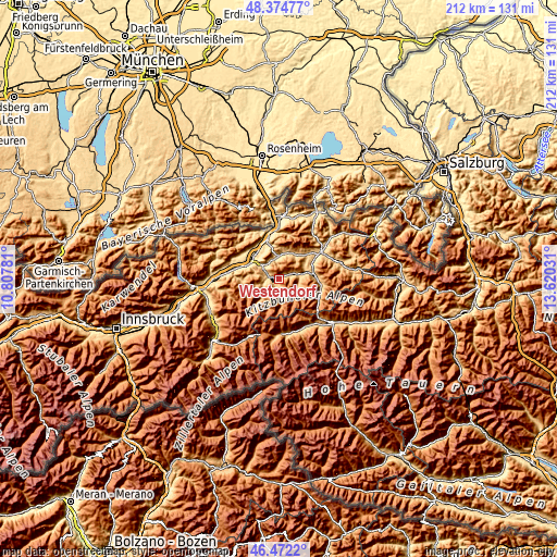
| \ | Map #1 | Map #2 | Topo.Map |
| Scale [m] | 635..1872 m | 542..2000 m | × |
| Scale [ft] | 2083..6142 ft | 1778..6562 ft | × |
| Average | 1024.6 m = 3362 ft | 1111.7 m = 3647 ft | × |
| Width | 6.61 km = 4.1 mi | 13.22 km = 8.2 mi | 211.5 km = 131.4 mi |
| Height | 6.61 km = 4.1 mi | 13.22 km = 8.2 mi | 211.5 km = 131.4 mi |
| ↑Max Latitude | 47.461799° | 47.491501° | 48.37477° |
| Latitude at center | 47.43208° | 47.43208° | 47.43208° |
| ↓Min Latitude | 47.402344° | 47.372592° | 46.4722° |
| ← Min Longitude | 12.170115° | 12.126169° | 10.80781° |
| Longitude center | 12.21406° | 12.21406° | 12.21406° |
| →Max Longitude | 12.258005° | 12.301951° | 13.62031° |
Nearby cities:
Cities around Westendorf sort by population:
• Kirchberg in Tirol elevation 823 m
7.8 km,  79°
79°
• Söll 691 m
8.1 km,  348°
348°
• Ellmau 791 m
11.1 km,  35°
35°
• Bad Häring 589 m
11.3 km,  320°
320°
• Hopfgarten im Brixental 610 m
4.7 km,  294°
294°
• Brixen im Thale 798 m
3.4 km,  53°
53°
• Oberau 930 m
12.5 km,  275°
275°
• Reith bei Kitzbühel 766 m
10.9 km,  69°
69°
• Scheffau am Wilden Kaiser 749 m
11.2 km,  14°
14°
• Itter 613 m
7.2 km,  302°
302°
• Niederau 819 m
10 km, 281°
• Going 765 m
12.6 km, 44°
Multilingual:
 En español:
Westendorf elevación 782 m.
 En France:
Westendorf élévation 782 m.
 Auf Deutsch:
Westendorf höhe über dem Meeresspiegel ist 782 m.

Sources and notes:
- [note 1] Map square and city borders are not equal. Map elevation data is calculated only from area inside that square.
- [src 1] Elevation data from geonames database provided with same terms of usage.
- [src 2] The elevation map of Westendorf is generated using elevation data from NASA's 3 arcsec (90m) resolution SRTM data.
- [src 3] Base (background) map © OpenStreetMap contributors tiles are generated by Geofabrik and OpenTopoMap.
Copyright & License:
This Westendorf Elevation Map is licensed under CC BY-SA. You may reuse any part from this page, if you give a proper credit by linking to this URL:
 More info on terms of use page.