Bad Schallerbach elevation
Bad Schallerbach (Upper Austria, Politischer Bezirk Grieskirchen), Austria elevation is 309 meters and Bad Schallerbach elevation in feet is 1014 ft above sea level [src 1]. Bad Schallerbach is a populated place (feature code) with elevation that is 200 meters (656 ft) smaller than average city elevation in Austria.
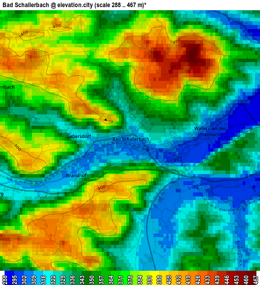
Below is the Elevation map of Bad Schallerbach, which displays elevation range with different colors. Scale of the first map is from 288 to 467 m (945 to 1532 ft) with average elevation of 358.5 meters (=1176 ft) [note 1]
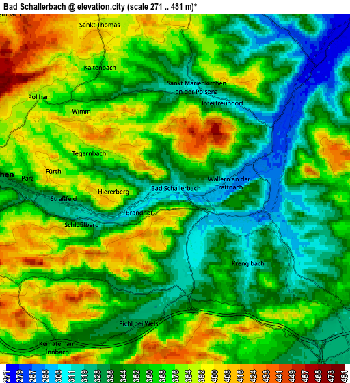
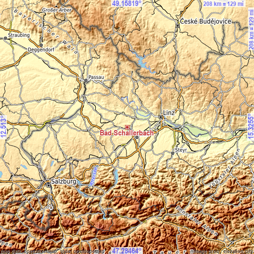
These maps also provides idea of topography and contour of this city, they are displayed at different zoom levels. More info about maps, scale and edge coordinates you can find below images.
| \ | Map #1 | Map #2 | Topo.Map |
| Scale [m] | 288..467 m | 271..481 m | × |
| Scale [ft] | 945..1532 ft | 889..1578 ft | × |
| Average | 358.5 m = 1176 ft | 360.3 m = 1182 ft | × |
| Width | 6.51 km = 4 mi | 13.02 km = 8.1 mi | 208.3 km = 129.4 mi |
| Height | 6.51 km = 4 mi | 13.02 km = 8.1 mi | 208.3 km = 129.4 mi |
| ↑Max Latitude | 48.259255° | 48.288504° | 49.15819° |
| Latitude at center | 48.22999° | 48.22999° | 48.22999° |
| ↓Min Latitude | 48.200708° | 48.171409° | 47.28464° |
| ← Min Longitude | 13.875305° | 13.831359° | 12.513° |
| Longitude center | 13.91925° | 13.91925° | 13.91925° |
| →Max Longitude | 13.963195° | 14.007141° | 15.3255° |
Nearby cities:
Cities around Bad Schallerbach sort by population:
• Wimpassing elevation 332 m
8.5 km,  145°
145°
• Oberhaid 322 m
9.3 km,  130°
130°
• Laahen 324 m
9.1 km,  135°
135°
• Grieskirchen 334 m
6.4 km,  273°
273°
• Wispl 323 m
9.3 km, 141°
• Wallern an der Trattnach 300 m
2 km,  80°
80°
• Gallspach 375 m
8.4 km,  254°
254°
• Prambachkirchen 374 m
9.7 km,  353°
353°
• Schlüsslberg 322 m
3.7 km, 250°
• Pichl bei Wels 329 m
5.2 km,  196°
196°
• Buchkirchen 337 m
7.7 km,  94°
94°
• Michaelnbach 392 m
9.1 km,  314°
314°
Multilingual:
 En español:
Bad Schallerbach elevación 309 m.
 En France:
Bad Schallerbach élévation 309 m.
 Auf Deutsch:
Bad Schallerbach höhe über dem Meeresspiegel ist 309 m.

Sources and notes:
- [note 1] Map square and city borders are not equal. Map elevation data is calculated only from area inside that square.
- [src 1] Elevation data from geonames database provided with same terms of usage.
- [src 2] The elevation map of Bad Schallerbach is generated using elevation data from NASA's 3 arcsec (90m) resolution SRTM data.
- [src 3] Base (background) map © OpenStreetMap contributors tiles are generated by Geofabrik and OpenTopoMap.
Copyright & License:
This Bad Schallerbach Elevation Map is licensed under CC BY-SA. You may reuse any part from this page, if you give a proper credit by linking to this URL:
 More info on terms of use page.