Oberhaid elevation
Oberhaid (Upper Austria, Wels Stadt), Austria elevation is 322 meters and Oberhaid elevation in feet is 1056 ft above sea level [src 1]. Oberhaid is a section of populated place (feature code) with elevation that is 187 meters (614 ft) smaller than average city elevation in Austria.
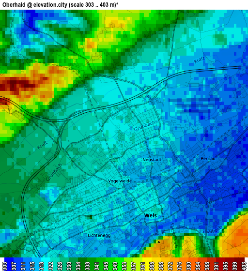
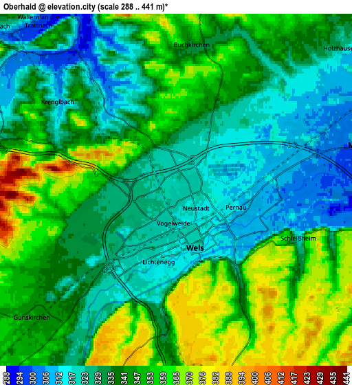
Below is the Elevation map of Oberhaid, which displays elevation range with different colors. Scale of the first map is from 303 to 403 m (994 to 1322 ft) with average elevation of 326.9 meters (=1073 ft) [note 1]
These maps also provides idea of topography and contour of this city, they are displayed at different zoom levels. More info about maps, scale and edge coordinates you can find below images.
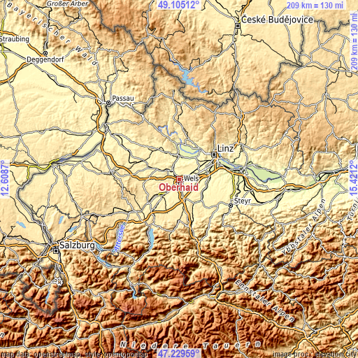
| \ | Map #1 | Map #2 | Topo.Map |
| Scale [m] | 303..403 m | 288..441 m | × |
| Scale [ft] | 994..1322 ft | 945..1447 ft | × |
| Average | 326.9 m = 1073 ft | 339.9 m = 1115 ft | × |
| Width | 6.52 km = 4.1 mi | 13.03 km = 8.1 mi | 208.5 km = 129.6 mi |
| Height | 6.52 km = 4.1 mi | 13.03 km = 8.1 mi | 208.5 km = 129.6 mi |
| ↑Max Latitude | 48.205226° | 48.234506° | 49.10512° |
| Latitude at center | 48.17593° | 48.17593° | 48.17593° |
| ↓Min Latitude | 48.146617° | 48.117287° | 47.22959° |
| ← Min Longitude | 13.971005° | 13.927059° | 12.6087° |
| Longitude center | 14.01495° | 14.01495° | 14.01495° |
| →Max Longitude | 14.058895° | 14.102841° | 15.4212° |
Nearby cities:
Cities around Oberhaid sort by population:
• Wels elevation 317 m
1.7 km,  127°
127°
• Lichtenegg 314 m
3.1 km,  201°
201°
• Wimpassing 332 m
2.6 km,  246°
246°
• Laahen 324 m
0.8 km,  234°
234°
• Bernardin 318 m
1.8 km, 195°
• Thalheim bei Wels 339 m
3.2 km,  154°
154°
• Wispl 323 m
1.8 km, 226°
• Haidl 309 m
2.8 km,  97°
97°
• Hochpoint 312 m
2.4 km, 132°
• Oberhart 314 m
2.7 km,  72°
72°
• Untereisenfeld 314 m
2.1 km,  114°
114°
• Dickerldorf 311 m
3.1 km,  88°
88°
Multilingual:
 En español:
Oberhaid elevación 322 m.
 En France:
Oberhaid élévation 322 m.
 Auf Deutsch:
Oberhaid höhe über dem Meeresspiegel ist 322 m.

Sources and notes:
- [note 1] Map square and city borders are not equal. Map elevation data is calculated only from area inside that square.
- [src 1] Elevation data from geonames database provided with same terms of usage.
- [src 2] The elevation map of Oberhaid is generated using elevation data from NASA's 3 arcsec (90m) resolution SRTM data.
- [src 3] Base (background) map © OpenStreetMap contributors tiles are generated by Geofabrik and OpenTopoMap.
Copyright & License:
This Oberhaid Elevation Map is licensed under CC BY-SA. You may reuse any part from this page, if you give a proper credit by linking to this URL:
 More info on terms of use page.