Thalheim bei Wels elevation
Thalheim bei Wels (Upper Austria, Wels-Land), Austria elevation is 339 meters and Thalheim bei Wels elevation in feet is 1112 ft above sea level [src 1]. Thalheim bei Wels is a seat of a third-order administrative division (feature code) with elevation that is 170 meters (558 ft) smaller than average city elevation in Austria.
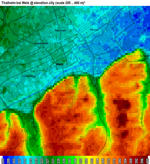
Below is the Elevation map of Thalheim bei Wels, which displays elevation range with different colors. Scale of the first map is from 295 to 400 m (968 to 1312 ft) with average elevation of 342.5 meters (=1124 ft) [note 1]
These maps also provides idea of topography and contour of this city, they are displayed at different zoom levels. More info about maps, scale and edge coordinates you can find below images.
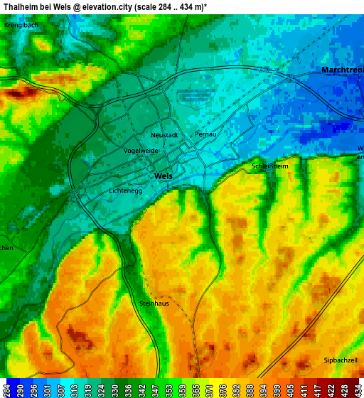
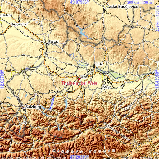
| \ | Map #1 | Map #2 | Topo.Map |
| Scale [m] | 295..400 m | 284..434 m | × |
| Scale [ft] | 968..1312 ft | 932..1424 ft | × |
| Average | 342.5 m = 1124 ft | 348.4 m = 1143 ft | × |
| Width | 6.52 km = 4.1 mi | 13.04 km = 8.1 mi | 208.6 km = 129.6 mi |
| Height | 6.52 km = 4.1 mi | 13.04 km = 8.1 mi | 208.6 km = 129.6 mi |
| ↑Max Latitude | 48.179311° | 48.208606° | 49.07966° |
| Latitude at center | 48.15° | 48.15° | 48.15° |
| ↓Min Latitude | 48.120672° | 48.091327° | 47.20319° |
| ← Min Longitude | 13.989385° | 13.945439° | 12.62708° |
| Longitude center | 14.03333° | 14.03333° | 14.03333° |
| →Max Longitude | 14.077275° | 14.121221° | 15.43958° |
Nearby cities:
Cities around Thalheim bei Wels sort by population:
• Wels elevation 317 m
1.9 km,  0°
0°
• Lichtenegg 314 m
2.5 km,  270°
270°
• Oberhaid 322 m
3.2 km,  334°
334°
• Laahen 324 m
3.2 km,  320°
320°
• Bernardin 318 m
2.2 km,  302°
302°
• Brandln 321 m
2.9 km,  259°
259°
• Schafwiesen 306 m
3.1 km,  53°
53°
• Wispl 323 m
3.1 km, 301°
• Haidl 309 m
2.9 km,  30°
30°
• Hochpoint 312 m
1.3 km,  16°
16°
• Untereisenfeld 314 m
2.1 km, 15°
• Dickerldorf 311 m
3.5 km, 30°
Multilingual:
 En español:
Thalheim bei Wels elevación 339 m.
 En France:
Thalheim bei Wels élévation 339 m.
 Auf Deutsch:
Thalheim bei Wels höhe über dem Meeresspiegel ist 339 m.
 На русском:
Тальхайм-Вельс, Тальхайм-бай-Вельс высота над уровнем моря 339 м
Sources and notes:
- [note 1] Map square and city borders are not equal. Map elevation data is calculated only from area inside that square.
- [src 1] Elevation data from geonames database provided with same terms of usage.
- [src 2] The elevation map of Thalheim bei Wels is generated using elevation data from NASA's 3 arcsec (90m) resolution SRTM data.
- [src 3] Base (background) map © OpenStreetMap contributors tiles are generated by Geofabrik and OpenTopoMap.
Copyright & License:
This Thalheim bei Wels Elevation Map is licensed under CC BY-SA. You may reuse any part from this page, if you give a proper credit by linking to this URL:
 More info on terms of use page.