Buchkirchen elevation
Buchkirchen (Upper Austria, Wels-Land), Austria elevation is 337 meters and Buchkirchen elevation in feet is 1106 ft above sea level [src 1]. Buchkirchen is a seat of a third-order administrative division (feature code) with elevation that is 172 meters (564 ft) smaller than average city elevation in Austria.
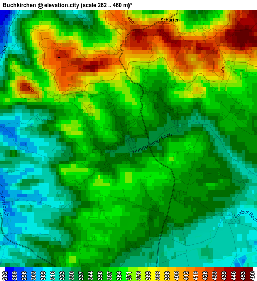
Below is the Elevation map of Buchkirchen, which displays elevation range with different colors. Scale of the first map is from 282 to 460 m (925 to 1509 ft) with average elevation of 355.7 meters (=1167 ft) [note 1]
These maps also provides idea of topography and contour of this city, they are displayed at different zoom levels. More info about maps, scale and edge coordinates you can find below images.
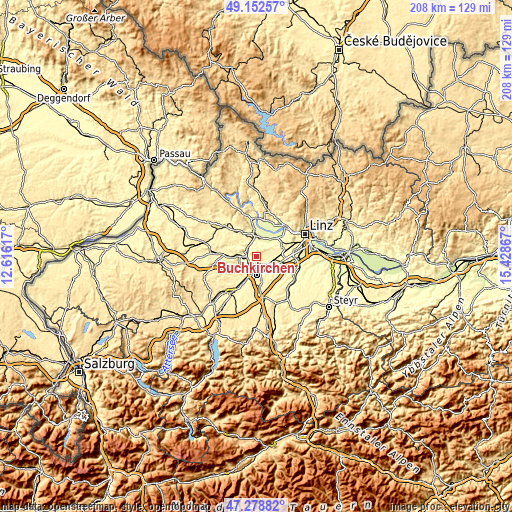
| \ | Map #1 | Topo.Map |
| Scale [m] | 282..460 m | × |
| Scale [ft] | 925..1509 ft | × |
| Average | 355.7 m = 1167 ft | × |
| Width | 6.51 km = 4 mi | 208.3 km = 129.4 mi |
| Height | 6.51 km = 4 mi | 208.3 km = 129.4 mi |
| ↑Max Latitude | 48.253539° | 49.15257° |
| Latitude at center | 48.22427° | 48.22427° |
| ↓Min Latitude | 48.194985° | 47.27882° |
| ← Min Longitude | 13.978475° | 12.61617° |
| Longitude center | 14.02242° | 14.02242° |
| →Max Longitude | 14.066365° | 15.42867° |
Nearby cities:
Cities around Buchkirchen sort by population:
• Wels elevation 317 m
6.5 km,  172°
172°
• Wimpassing 332 m
7 km,  204°
204°
• Oberhaid 322 m
5.4 km,  185°
185°
• Laahen 324 m
5.9 km, 191°
• Wispl 323 m
6.9 km, 195°
• Wallern an der Trattnach 300 m
5.7 km,  279°
279°
• Haidl 309 m
6.2 km,  158°
158°
• Hochpoint 312 m
7.1 km, 170°
• Oberhart 314 m
5 km, 155°
• Untereisenfeld 314 m
6.4 km, 167°
• Dickerldorf 311 m
5.9 km,  154°
154°
• Holzhausen 328 m
5.5 km,  91°
91°
Multilingual:
 En español:
Buchkirchen elevación 337 m.
 En France:
Buchkirchen élévation 337 m.
 Auf Deutsch:
Buchkirchen höhe über dem Meeresspiegel ist 337 m.

Sources and notes:
- [note 1] Map square and city borders are not equal. Map elevation data is calculated only from area inside that square.
- [src 1] Elevation data from geonames database provided with same terms of usage.
- [src 2] The elevation map of Buchkirchen is generated using elevation data from NASA's 3 arcsec (90m) resolution SRTM data.
- [src 3] Base (background) map © OpenStreetMap contributors tiles are generated by Geofabrik and OpenTopoMap.
Copyright & License:
This Buchkirchen Elevation Map is licensed under CC BY-SA. You may reuse any part from this page, if you give a proper credit by linking to this URL:
 More info on terms of use page.