Bad Schönau elevation
Bad Schönau (Lower Austria, Politischer Bezirk Wiener Neustadt), Austria elevation is 477 meters and Bad Schönau elevation in feet is 1565 ft above sea level [src 1]. Bad Schönau is a seat of a third-order administrative division (feature code) with elevation that is 32 meters (105 ft) smaller than average city elevation in Austria.
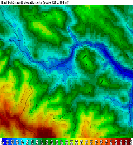
Below is the Elevation map of Bad Schönau, which displays elevation range with different colors. Scale of the first map is from 427 to 881 m (1401 to 2890 ft) with average elevation of 592.4 meters (=1944 ft) [note 1]
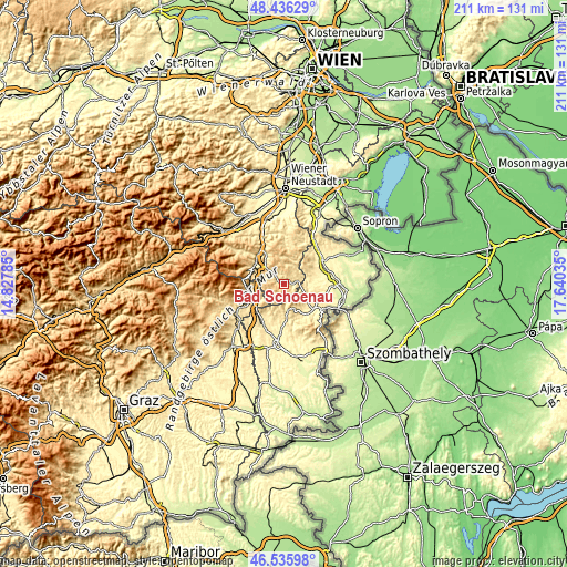
These maps also provides idea of topography and contour of this city, they are displayed at different zoom levels. More info about maps, scale and edge coordinates you can find below images.
| \ | Map #1 | Topo.Map |
| Scale [m] | 427..881 m | × |
| Scale [ft] | 1401..2890 ft | × |
| Average | 592.4 m = 1944 ft | × |
| Width | 6.6 km = 4.1 mi | 211.3 km = 131.3 mi |
| Height | 6.6 km = 4.1 mi | 211.3 km = 131.3 mi |
| ↑Max Latitude | 47.524414° | 48.43629° |
| Latitude at center | 47.49473° | 47.49473° |
| ↓Min Latitude | 47.46503° | 46.53598° |
| ← Min Longitude | 16.190155° | 14.82785° |
| Longitude center | 16.2341° | 16.2341° |
| →Max Longitude | 16.278045° | 17.64035° |
Nearby cities:
Cities around Bad Schönau sort by population:
• Krumbach Markt elevation 640 m
4.5 km,  302°
302°
• Kirchschlag in der Buckligen Welt 527 m
3.7 km,  80°
80°
• Bernstein 527 m
10.6 km,  173°
173°
• Zöbern 630 m
8 km,  285°
285°
• Kaisersdorf 362 m
12.8 km,  68°
68°
• Pilgersdorf 365 m
10.5 km,  124°
124°
• Thomasberg 674 m
11 km,  316°
316°
• Schäffern 598 m
9.5 km,  258°
258°
• Hollenthon 660 m
10.7 km,  10°
10°
• Weingraben 409 m
10 km, 77°
• Lichtenegg 757 m
12 km,  347°
347°
• Tiefenbach 545 m
4.8 km,  341°
341°
Multilingual:
 En español:
Bad Schönau elevación 477 m.
 En France:
Bad Schönau élévation 477 m.
 Auf Deutsch:
Bad Schönau höhe über dem Meeresspiegel ist 477 m.

Sources and notes:
- [note 1] Map square and city borders are not equal. Map elevation data is calculated only from area inside that square.
- [src 1] Elevation data from geonames database provided with same terms of usage.
- [src 2] The elevation map of Bad Schönau is generated using elevation data from NASA's 3 arcsec (90m) resolution SRTM data.
- [src 3] Base (background) map © OpenStreetMap contributors tiles are generated by Geofabrik and OpenTopoMap.
Copyright & License:
This Bad Schönau Elevation Map is licensed under CC BY-SA. You may reuse any part from this page, if you give a proper credit by linking to this URL:
 More info on terms of use page.