Bernstein elevation
Bernstein (Burgenland, Politischer Bezirk Oberwart), Austria elevation is 527 meters and Bernstein elevation in feet is 1729 ft above sea level [src 1]. Bernstein is a seat of a third-order administrative division (feature code) with elevation that is 18 meters (59 ft) bigger than average city elevation in Austria.
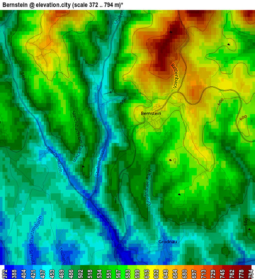
Below is the Elevation map of Bernstein, which displays elevation range with different colors. Scale of the first map is from 372 to 794 m (1220 to 2605 ft) with average elevation of 533 meters (=1749 ft) [note 1]
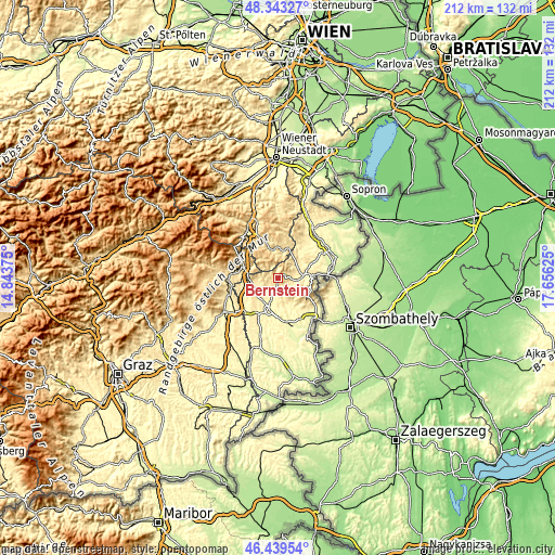
These maps also provides idea of topography and contour of this city, they are displayed at different zoom levels. More info about maps, scale and edge coordinates you can find below images.
| \ | Map #1 | Topo.Map |
| Scale [m] | 372..794 m | × |
| Scale [ft] | 1220..2605 ft | × |
| Average | 533 m = 1749 ft | × |
| Width | 6.61 km = 4.1 mi | 211.7 km = 131.5 mi |
| Height | 6.61 km = 4.1 mi | 211.7 km = 131.5 mi |
| ↑Max Latitude | 47.429737° | 48.34327° |
| Latitude at center | 47.4° | 47.4° |
| ↓Min Latitude | 47.370246° | 46.43954° |
| ← Min Longitude | 16.206055° | 14.84375° |
| Longitude center | 16.25° | 16.25° |
| →Max Longitude | 16.293945° | 17.65625° |
Nearby cities:
Cities around Bernstein sort by population:
• Pinkafeld elevation 389 m
10.7 km,  249°
249°
• Riedlingsdorf 374 m
10.4 km,  237°
237°
• Kirchschlag in der Buckligen Welt 527 m
11.4 km,  12°
12°
• Oberschützen 355 m
6.3 km,  210°
210°
• Lockenhaus 326 m
12.5 km,  86°
86°
• Wiesfleck 393 m
8 km,  257°
257°
• Bad Tatzmannsdorf 340 m
7.8 km,  190°
190°
• Stadtschlaining 343 m
9.6 km,  164°
164°
• Pilgersdorf 365 m
8.7 km,  58°
58°
• Bad Schönau 477 m
10.6 km,  353°
353°
• Mariasdorf 395 m
4.1 km,  200°
200°
• Unterkohlstätten 476 m
5.3 km,  110°
110°
Multilingual:
 En español:
Bernstein elevación 527 m.
 En France:
Bernstein élévation 527 m.
 Auf Deutsch:
Bernstein höhe über dem Meeresspiegel ist 527 m.

Sources and notes:
- [note 1] Map square and city borders are not equal. Map elevation data is calculated only from area inside that square.
- [src 1] Elevation data from geonames database provided with same terms of usage.
- [src 2] The elevation map of Bernstein is generated using elevation data from NASA's 3 arcsec (90m) resolution SRTM data.
- [src 3] Base (background) map © OpenStreetMap contributors tiles are generated by Geofabrik and OpenTopoMap.
Copyright & License:
This Bernstein Elevation Map is licensed under CC BY-SA. You may reuse any part from this page, if you give a proper credit by linking to this URL:
 More info on terms of use page.