Pinkafeld elevation
Pinkafeld (Burgenland, Politischer Bezirk Oberwart), Austria elevation is 389 meters and Pinkafeld elevation in feet is 1276 ft above sea level [src 1]. Pinkafeld is a seat of a third-order administrative division (feature code) with elevation that is 120 meters (394 ft) smaller than average city elevation in Austria.
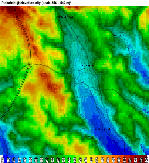
Below is the Elevation map of Pinkafeld, which displays elevation range with different colors. Scale of the first map is from 356 to 542 m (1168 to 1778 ft) with average elevation of 430.7 meters (=1413 ft) [note 1]
These maps also provides idea of topography and contour of this city, they are displayed at different zoom levels. More info about maps, scale and edge coordinates you can find below images.
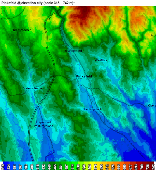
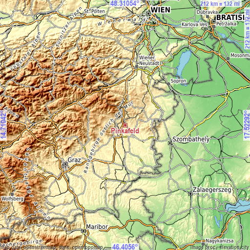
| \ | Map #1 | Map #2 | Topo.Map |
| Scale [m] | 356..542 m | 318..742 m | × |
| Scale [ft] | 1168..1778 ft | 1043..2434 ft | × |
| Average | 430.7 m = 1413 ft | 448 m = 1470 ft | × |
| Width | 6.62 km = 4.1 mi | 13.24 km = 8.2 mi | 211.8 km = 131.6 mi |
| Height | 6.62 km = 4.1 mi | 13.24 km = 8.2 mi | 211.8 km = 131.6 mi |
| ↑Max Latitude | 47.396426° | 47.426165° | 48.31054° |
| Latitude at center | 47.36667° | 47.36667° | 47.36667° |
| ↓Min Latitude | 47.336897° | 47.307108° | 46.4056° |
| ← Min Longitude | 16.072725° | 16.028779° | 14.71042° |
| Longitude center | 16.11667° | 16.11667° | 16.11667° |
| →Max Longitude | 16.160615° | 16.204561° | 17.52292° |
Nearby cities:
Cities around Pinkafeld sort by population:
• Riedlingsdorf elevation 374 m
2.2 km,  145°
145°
• Pinggau 597 m
9.2 km,  336°
336°
• Oberschützen 355 m
7 km,  103°
103°
• Rohrbach an der Lafnitz 433 m
9 km,  281°
281°
• Grafenschachen 419 m
3.8 km,  270°
270°
• Lafnitz 402 m
8 km, 271°
• Wiesfleck 393 m
2.9 km,  47°
47°
• Neustift an der Lafnitz 452 m
6.3 km, 270°
• Bad Tatzmannsdorf 340 m
9.4 km,  114°
114°
• Dechantskirchen 530 m
9.4 km,  306°
306°
• Mariasdorf 395 m
8.6 km,  90°
90°
• Friedberg 552 m
9 km,  325°
325°
Multilingual:
 En español:
Pinkafeld elevación 389 m.
 En France:
Pinkafeld élévation 389 m.
 Auf Deutsch:
Pinkafeld höhe über dem Meeresspiegel ist 389 m.

Sources and notes:
- [note 1] Map square and city borders are not equal. Map elevation data is calculated only from area inside that square.
- [src 1] Elevation data from geonames database provided with same terms of usage.
- [src 2] The elevation map of Pinkafeld is generated using elevation data from NASA's 3 arcsec (90m) resolution SRTM data.
- [src 3] Base (background) map © OpenStreetMap contributors tiles are generated by Geofabrik and OpenTopoMap.
Copyright & License:
This Pinkafeld Elevation Map is licensed under CC BY-SA. You may reuse any part from this page, if you give a proper credit by linking to this URL:
 More info on terms of use page.