Stadtschlaining elevation
Stadtschlaining (Burgenland, Politischer Bezirk Oberwart), Austria elevation is 343 meters and Stadtschlaining elevation in feet is 1125 ft above sea level [src 1]. Stadtschlaining is a seat of a third-order administrative division (feature code) with elevation that is 166 meters (545 ft) smaller than average city elevation in Austria.
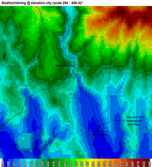
Below is the Elevation map of Stadtschlaining, which displays elevation range with different colors. Scale of the first map is from 294 to 646 m (965 to 2119 ft) with average elevation of 392 meters (=1286 ft) [note 1]
These maps also provides idea of topography and contour of this city, they are displayed at different zoom levels. More info about maps, scale and edge coordinates you can find below images.
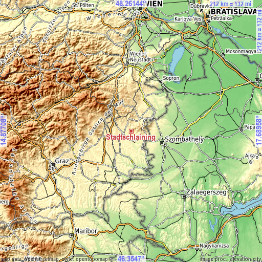
| \ | Map #1 | Topo.Map |
| Scale [m] | 294..646 m | × |
| Scale [ft] | 965..2119 ft | × |
| Average | 392 m = 1286 ft | × |
| Width | 6.63 km = 4.1 mi | 212 km = 131.7 mi |
| Height | 6.63 km = 4.1 mi | 212 km = 131.7 mi |
| ↑Max Latitude | 47.346454° | 48.26144° |
| Latitude at center | 47.31667° | 47.31667° |
| ↓Min Latitude | 47.286869° | 46.3547° |
| ← Min Longitude | 16.239385° | 14.87708° |
| Longitude center | 16.28333° | 16.28333° |
| →Max Longitude | 16.327275° | 17.68958° |
Nearby cities:
Cities around Stadtschlaining sort by population:
• Oberwart elevation 316 m
6.6 km,  242°
242°
• Grosspetersdorf 310 m
9 km,  163°
163°
• Oberschützen 355 m
6.9 km,  303°
303°
• Bernstein 527 m
9.6 km,  344°
344°
• Rotenturm an der Pinka 293 m
7.8 km,  198°
198°
• Jabing 277 m
8.7 km,  183°
183°
• Unterwart 338 m
8.3 km,  206°
206°
• Bad Tatzmannsdorf 340 m
4.3 km,  292°
292°
• Markt Neuhodis 317 m
8.8 km,  105°
105°
• Mariasdorf 395 m
6.7 km,  324°
324°
• Unterkohlstätten 476 m
7.8 km,  18°
18°
• Weiden bei Rechnitz 337 m
5.4 km, 110°
Multilingual:
 En español:
Stadtschlaining elevación 343 m.
 En France:
Stadtschlaining élévation 343 m.
 Auf Deutsch:
Stadtschlaining höhe über dem Meeresspiegel ist 343 m.

Sources and notes:
- [note 1] Map square and city borders are not equal. Map elevation data is calculated only from area inside that square.
- [src 1] Elevation data from geonames database provided with same terms of usage.
- [src 2] The elevation map of Stadtschlaining is generated using elevation data from NASA's 3 arcsec (90m) resolution SRTM data.
- [src 3] Base (background) map © OpenStreetMap contributors tiles are generated by Geofabrik and OpenTopoMap.
Copyright & License:
This Stadtschlaining Elevation Map is licensed under CC BY-SA. You may reuse any part from this page, if you give a proper credit by linking to this URL:
 More info on terms of use page.