Jabing elevation
Jabing (Burgenland, Politischer Bezirk Oberwart), Austria elevation is 277 meters and Jabing elevation in feet is 909 ft above sea level [src 1]. Jabing is a seat of a third-order administrative division (feature code) with elevation that is 232 meters (761 ft) smaller than average city elevation in Austria.
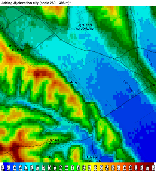
Below is the Elevation map of Jabing, which displays elevation range with different colors. Scale of the first map is from 260 to 396 m (853 to 1299 ft) with average elevation of 301.2 meters (=988 ft) [note 1]
These maps also provides idea of topography and contour of this city, they are displayed at different zoom levels. More info about maps, scale and edge coordinates you can find below images.
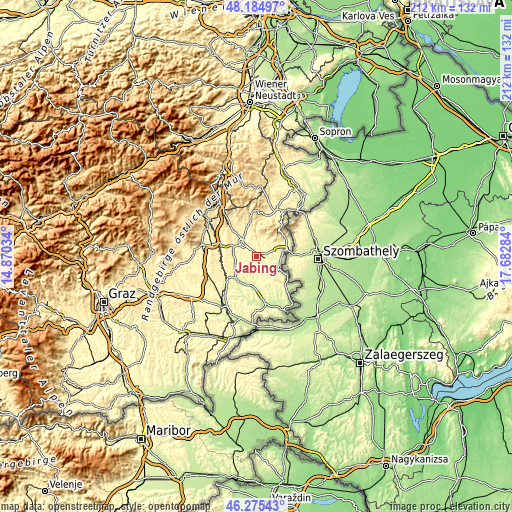
| \ | Map #1 | Topo.Map |
| Scale [m] | 260..396 m | × |
| Scale [ft] | 853..1299 ft | × |
| Average | 301.2 m = 988 ft | × |
| Width | 6.63 km = 4.1 mi | 212.3 km = 131.9 mi |
| Height | 6.64 km = 4.1 mi | 212.3 km = 131.9 mi |
| ↑Max Latitude | 47.268628° | 48.18497° |
| Latitude at center | 47.2388° | 47.2388° |
| ↓Min Latitude | 47.208955° | 46.27543° |
| ← Min Longitude | 16.232645° | 14.87034° |
| Longitude center | 16.27659° | 16.27659° |
| →Max Longitude | 16.320535° | 17.68284° |
Nearby cities:
Cities around Jabing sort by population:
• Oberwart elevation 316 m
7.8 km,  316°
316°
• Grosspetersdorf 310 m
3.1 km,  89°
89°
• Olbendorf 310 m
8.5 km,  223°
223°
• Litzelsdorf 332 m
8.6 km,  246°
246°
• Oberdorf im Burgenland 310 m
5.2 km,  241°
241°
• Neuberg im Burgenland 303 m
7.9 km,  188°
188°
• Rotenturm an der Pinka 293 m
2.4 km,  301°
301°
• Unterwart 338 m
3.5 km,  290°
290°
• Stadtschlaining 343 m
8.7 km,  3°
3°
• Mischendorf 271 m
5.9 km,  150°
150°
• Hannersdorf 255 m
8.1 km,  97°
97°
• Badersdorf 261 m
8.1 km,  122°
122°
Multilingual:
 En español:
Jabing elevación 277 m.
 En France:
Jabing élévation 277 m.


Sources and notes:
- [note 1] Map square and city borders are not equal. Map elevation data is calculated only from area inside that square.
- [src 1] Elevation data from geonames database provided with same terms of usage.
- [src 2] The elevation map of Jabing is generated using elevation data from NASA's 3 arcsec (90m) resolution SRTM data.
- [src 3] Base (background) map © OpenStreetMap contributors tiles are generated by Geofabrik and OpenTopoMap.
Copyright & License:
This Jabing Elevation Map is licensed under CC BY-SA. You may reuse any part from this page, if you give a proper credit by linking to this URL:
 More info on terms of use page.