Hannersdorf elevation
Hannersdorf (Burgenland, Politischer Bezirk Oberwart), Austria elevation is 255 meters and Hannersdorf elevation in feet is 837 ft above sea level [src 1]. Hannersdorf is a seat of a third-order administrative division (feature code) with elevation that is 254 meters (833 ft) smaller than average city elevation in Austria.
Below is the Elevation map of Hannersdorf, which displays elevation range with different colors. Scale of the first map is from 240 to 410 m (787 to 1345 ft) with average elevation of 286 meters (=938 ft) [note 1]
These maps also provides idea of topography and contour of this city, they are displayed at different zoom levels. More info about maps, scale and edge coordinates you can find below images.
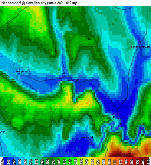
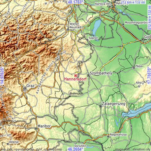
| \ | Map #1 | Topo.Map |
| Scale [m] | 240..410 m | × |
| Scale [ft] | 787..1345 ft | × |
| Average | 286 m = 938 ft | × |
| Width | 6.64 km = 4.1 mi | 212.4 km = 132 mi |
| Height | 6.64 km = 4.1 mi | 212.3 km = 131.9 mi |
| ↑Max Latitude | 47.258784° | 48.1753° |
| Latitude at center | 47.22895° | 47.22895° |
| ↓Min Latitude | 47.1991° | 46.2654° |
| ← Min Longitude | 16.338555° | 14.97625° |
| Longitude center | 16.3825° | 16.3825° |
| →Max Longitude | 16.426445° | 17.78875° |
Nearby cities:
Cities around Hannersdorf sort by population:
• Rechnitz elevation 348 m
9.5 km,  27°
27°
• Grosspetersdorf 310 m
5 km,  282°
282°
• Rotenturm an der Pinka 293 m
10.3 km, 283°
• Kohfidisch 256 m
6.3 km,  197°
197°
• Güttenbach 284 m
10.5 km,  220°
220°
• Jabing 277 m
8.1 km, 277°
• Mischendorf 271 m
6.5 km,  231°
231°
• Markt Neuhodis 317 m
7.5 km,  7°
7°
• Schachendorf 279 m
5.7 km,  42°
42°
• Badersdorf 261 m
3.4 km, 200°
• Schandorf 261 m
3.4 km,  64°
64°
• Weiden bei Rechnitz 337 m
8.3 km,  342°
342°
Multilingual:
 En español:
Hannersdorf elevación 255 m.
 En France:
Hannersdorf élévation 255 m.
 Auf Deutsch:
Hannersdorf höhe über dem Meeresspiegel ist 255 m.

Sources and notes:
- [note 1] Map square and city borders are not equal. Map elevation data is calculated only from area inside that square.
- [src 1] Elevation data from geonames database provided with same terms of usage.
- [src 2] The elevation map of Hannersdorf is generated using elevation data from NASA's 3 arcsec (90m) resolution SRTM data.
- [src 3] Base (background) map © OpenStreetMap contributors tiles are generated by Geofabrik and OpenTopoMap.
Copyright & License:
This Hannersdorf Elevation Map is licensed under CC BY-SA. You may reuse any part from this page, if you give a proper credit by linking to this URL:
 More info on terms of use page.