Schäffern elevation
Schäffern (Styria, Politischer Bezirk Hartberg-Fürstenfeld), Austria elevation is 598 meters and Schäffern elevation in feet is 1962 ft above sea level [src 1]. Schäffern is a seat of a third-order administrative division (feature code) with elevation that is 89 meters (292 ft) bigger than average city elevation in Austria.
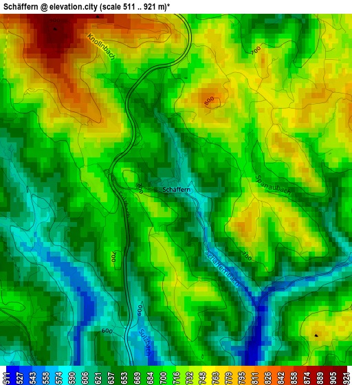
Below is the Elevation map of Schäffern, which displays elevation range with different colors. Scale of the first map is from 511 to 921 m (1677 to 3022 ft) with average elevation of 690.2 meters (=2264 ft) [note 1]
These maps also provides idea of topography and contour of this city, they are displayed at different zoom levels. More info about maps, scale and edge coordinates you can find below images.
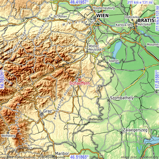
| \ | Map #1 | Topo.Map |
| Scale [m] | 511..921 m | × |
| Scale [ft] | 1677..3022 ft | × |
| Average | 690.2 m = 2264 ft | × |
| Width | 6.6 km = 4.1 mi | 211.4 km = 131.4 mi |
| Height | 6.6 km = 4.1 mi | 211.3 km = 131.3 mi |
| ↑Max Latitude | 47.507403° | 48.41957° |
| Latitude at center | 47.47771° | 47.47771° |
| ↓Min Latitude | 47.448° | 46.51865° |
| ← Min Longitude | 16.065615° | 14.70331° |
| Longitude center | 16.10956° | 16.10956° |
| →Max Longitude | 16.153505° | 17.51581° |
Nearby cities:
Cities around Schäffern sort by population:
• Krumbach Markt elevation 640 m
7 km,  51°
51°
• Aspang Markt 553 m
8.3 km,  346°
346°
• Pinggau 597 m
5.1 km,  219°
219°
• Ortgraben 719 m
5.4 km,  235°
235°
• Wiesfleck 393 m
10.7 km,  165°
165°
• Zöbern 630 m
4.4 km,  21°
21°
• Dechantskirchen 530 m
9.7 km,  225°
225°
• Mönichkirchen 983 m
6.7 km,  302°
302°
• Bad Schönau 477 m
9.5 km,  78°
78°
• Thomasberg 674 m
10.1 km,  10°
10°
• Friedberg 552 m
6.7 km, 222°
• Tiefenbach 545 m
10.1 km, 50°
Multilingual:
 En español:
Schäffern elevación 598 m.
 En France:
Schäffern élévation 598 m.
 Auf Deutsch:
Schäffern höhe über dem Meeresspiegel ist 598 m.

Sources and notes:
- [note 1] Map square and city borders are not equal. Map elevation data is calculated only from area inside that square.
- [src 1] Elevation data from geonames database provided with same terms of usage.
- [src 2] The elevation map of Schäffern is generated using elevation data from NASA's 3 arcsec (90m) resolution SRTM data.
- [src 3] Base (background) map © OpenStreetMap contributors tiles are generated by Geofabrik and OpenTopoMap.
Copyright & License:
This Schäffern Elevation Map is licensed under CC BY-SA. You may reuse any part from this page, if you give a proper credit by linking to this URL:
 More info on terms of use page.