Frohnleiten elevation
Frohnleiten (Styria, Politischer Bezirk Graz-Umgebung), Austria elevation is 416 meters and Frohnleiten elevation in feet is 1365 ft above sea level [src 1]. Frohnleiten is a seat of a third-order administrative division (feature code) with elevation that is 93 meters (305 ft) smaller than average city elevation in Austria.
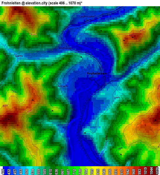
Below is the Elevation map of Frohnleiten, which displays elevation range with different colors. Scale of the first map is from 406 to 1070 m (1332 to 3510 ft) with average elevation of 629.6 meters (=2066 ft) [note 1]
These maps also provides idea of topography and contour of this city, they are displayed at different zoom levels. More info about maps, scale and edge coordinates you can find below images.
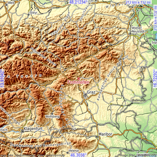
| \ | Map #1 | Topo.Map |
| Scale [m] | 406..1070 m | × |
| Scale [ft] | 1332..3510 ft | × |
| Average | 629.6 m = 2066 ft | × |
| Width | 6.63 km = 4.1 mi | 212.2 km = 131.9 mi |
| Height | 6.63 km = 4.1 mi | 212.2 km = 131.9 mi |
| ↑Max Latitude | 47.296482° | 48.21234° |
| Latitude at center | 47.26667° | 47.26667° |
| ↓Min Latitude | 47.236841° | 46.3038° |
| ← Min Longitude | 15.272725° | 13.91042° |
| Longitude center | 15.31667° | 15.31667° |
| →Max Longitude | 15.360615° | 16.72292° |
Nearby cities:
Cities around Frohnleiten sort by population:
• Gratkorn elevation 386 m
15 km,  170°
170°
• Kirchenviertel 376 m
15.2 km, 171°
• Deutschfeistritz 414 m
7.7 km, 168°
• Peggau 409 m
7.8 km,  161°
161°
• Passail 693 m
15.2 km,  83°
83°
• Semriach 695 m
8.4 km,  131°
131°
• Übelbach 570 m
7.6 km,  232°
232°
• Pernegg an der Mur 458 m
10.5 km,  10°
10°
• Arzberg 660 m
15.2 km,  97°
97°
• Schrems bei Frohnleiten 479 m
3.6 km,  63°
63°
• Geistthal 576 m
15.9 km, 225°
• Röthelstein 588 m
6.7 km,  34°
34°
Multilingual:
 En español:
Frohnleiten elevación 416 m.
 En France:
Frohnleiten élévation 416 m.
 Auf Deutsch:
Frohnleiten höhe über dem Meeresspiegel ist 416 m.

Sources and notes:
- [note 1] Map square and city borders are not equal. Map elevation data is calculated only from area inside that square.
- [src 1] Elevation data from geonames database provided with same terms of usage.
- [src 2] The elevation map of Frohnleiten is generated using elevation data from NASA's 3 arcsec (90m) resolution SRTM data.
- [src 3] Base (background) map © OpenStreetMap contributors tiles are generated by Geofabrik and OpenTopoMap.
Copyright & License:
This Frohnleiten Elevation Map is licensed under CC BY-SA. You may reuse any part from this page, if you give a proper credit by linking to this URL:
 More info on terms of use page.