Übelbach elevation
Übelbach (Styria, Politischer Bezirk Graz-Umgebung), Austria elevation is 570 meters and Übelbach elevation in feet is 1870 ft above sea level [src 1]. Übelbach is a seat of a third-order administrative division (feature code) with elevation that is 61 meters (200 ft) bigger than average city elevation in Austria.
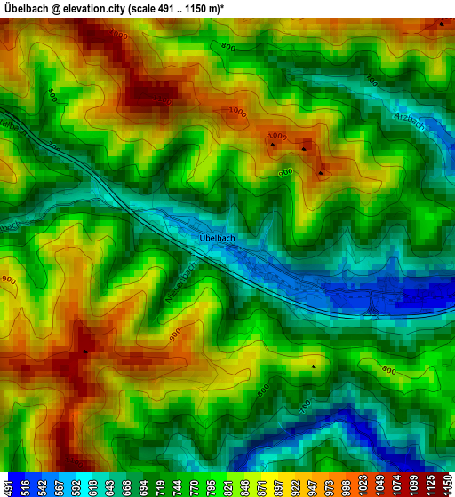
Below is the Elevation map of Übelbach, which displays elevation range with different colors. Scale of the first map is from 491 to 1150 m (1611 to 3773 ft) with average elevation of 793.1 meters (=2602 ft) [note 1]
These maps also provides idea of topography and contour of this city, they are displayed at different zoom levels. More info about maps, scale and edge coordinates you can find below images.
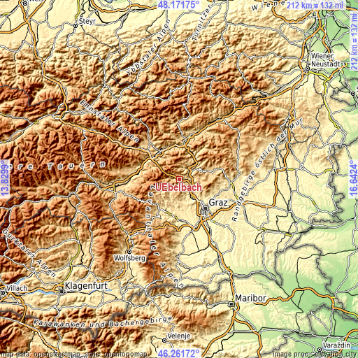
| \ | Map #1 | Topo.Map |
| Scale [m] | 491..1150 m | × |
| Scale [ft] | 1611..3773 ft | × |
| Average | 793.1 m = 2602 ft | × |
| Width | 6.64 km = 4.1 mi | 212.4 km = 132 mi |
| Height | 6.64 km = 4.1 mi | 212.4 km = 132 mi |
| ↑Max Latitude | 47.255176° | 48.17175° |
| Latitude at center | 47.22534° | 47.22534° |
| ↓Min Latitude | 47.195488° | 46.26172° |
| ← Min Longitude | 15.192205° | 13.8299° |
| Longitude center | 15.23615° | 15.23615° |
| →Max Longitude | 15.280095° | 16.6424° |
Nearby cities:
Cities around Übelbach sort by population:
• Gratkorn elevation 386 m
13.4 km,  139°
139°
• Kirchenviertel 376 m
13.4 km, 141°
• Gratwein 406 m
13.5 km,  153°
153°
• Frohnleiten 416 m
7.6 km,  52°
52°
• Deutschfeistritz 414 m
8.1 km,  111°
111°
• Peggau 409 m
9 km, 108°
• Semriach 695 m
12.4 km,  94°
94°
• Eisbach 463 m
12.3 km,  169°
169°
• Stiwoll 501 m
14 km,  186°
186°
• Schrems bei Frohnleiten 479 m
11.2 km,  56°
56°
• Geistthal 576 m
8.4 km,  218°
218°
• Gallmannsegg 1117 m
13.6 km,  249°
249°
Multilingual:
 En español:
Übelbach elevación 570 m.
 En France:
Übelbach élévation 570 m.
 Auf Deutsch:
Übelbach höhe über dem Meeresspiegel ist 570 m.

Sources and notes:
- [note 1] Map square and city borders are not equal. Map elevation data is calculated only from area inside that square.
- [src 1] Elevation data from geonames database provided with same terms of usage.
- [src 2] The elevation map of Übelbach is generated using elevation data from NASA's 3 arcsec (90m) resolution SRTM data.
- [src 3] Base (background) map © OpenStreetMap contributors tiles are generated by Geofabrik and OpenTopoMap.
Copyright & License:
This Übelbach Elevation Map is licensed under CC BY-SA. You may reuse any part from this page, if you give a proper credit by linking to this URL:
 More info on terms of use page.