Peggau elevation
Peggau (Styria, Politischer Bezirk Graz-Umgebung), Austria elevation is 409 meters and Peggau elevation in feet is 1342 ft above sea level [src 1]. Peggau is a seat of a third-order administrative division (feature code) with elevation that is 100 meters (328 ft) smaller than average city elevation in Austria.
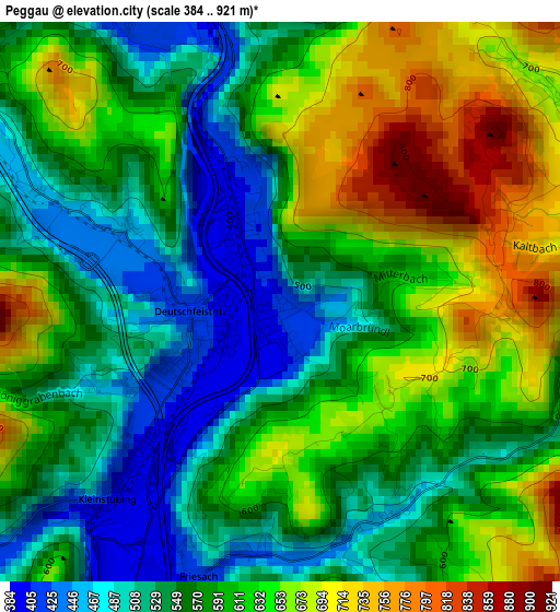
Below is the Elevation map of Peggau, which displays elevation range with different colors. Scale of the first map is from 384 to 921 m (1260 to 3022 ft) with average elevation of 590.2 meters (=1936 ft) [note 1]
These maps also provides idea of topography and contour of this city, they are displayed at different zoom levels. More info about maps, scale and edge coordinates you can find below images.
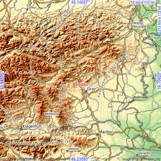
| \ | Map #1 | Topo.Map |
| Scale [m] | 384..921 m | × |
| Scale [ft] | 1260..3022 ft | × |
| Average | 590.2 m = 1936 ft | × |
| Width | 6.64 km = 4.1 mi | 212.5 km = 132 mi |
| Height | 6.64 km = 4.1 mi | 212.5 km = 132 mi |
| ↑Max Latitude | 47.22985° | 48.14687° |
| Latitude at center | 47.2° | 47.2° |
| ↓Min Latitude | 47.170133° | 46.23593° |
| ← Min Longitude | 15.306055° | 13.94375° |
| Longitude center | 15.35° | 15.35° |
| →Max Longitude | 15.393945° | 16.75625° |
Nearby cities:
Cities around Peggau sort by population:
• Gratkorn elevation 386 m
7.4 km,  180°
180°
• Kirchenviertel 376 m
7.6 km, 181°
• Gratwein 406 m
9.6 km,  195°
195°
• Frohnleiten 416 m
7.8 km,  341°
341°
• Strassengel 388 m
9.5 km,  187°
187°
• Deutschfeistritz 414 m
1.1 km,  261°
261°
• Judendorf 373 m
9.3 km, 180°
• Semriach 695 m
4.2 km,  63°
63°
• Übelbach 570 m
9 km,  288°
288°
• Sankt Radegund bei Graz 705 m
10.9 km,  100°
100°
• Schrems bei Frohnleiten 479 m
9 km,  4°
4°
• Stattegg 475 m
9 km,  145°
145°
Multilingual:
 En español:
Peggau elevación 409 m.
 En France:
Peggau élévation 409 m.


Sources and notes:
- [note 1] Map square and city borders are not equal. Map elevation data is calculated only from area inside that square.
- [src 1] Elevation data from geonames database provided with same terms of usage.
- [src 2] The elevation map of Peggau is generated using elevation data from NASA's 3 arcsec (90m) resolution SRTM data.
- [src 3] Base (background) map © OpenStreetMap contributors tiles are generated by Geofabrik and OpenTopoMap.
Copyright & License:
This Peggau Elevation Map is licensed under CC BY-SA. You may reuse any part from this page, if you give a proper credit by linking to this URL:
 More info on terms of use page.