Stiwoll elevation
Stiwoll (Styria, Politischer Bezirk Graz-Umgebung), Austria elevation is 501 meters and Stiwoll elevation in feet is 1644 ft above sea level [src 1]. Stiwoll is a seat of a third-order administrative division (feature code) with elevation that is 8 meters (26 ft) smaller than average city elevation in Austria.
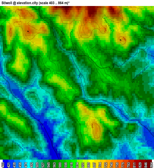
Below is the Elevation map of Stiwoll, which displays elevation range with different colors. Scale of the first map is from 403 to 864 m (1322 to 2835 ft) with average elevation of 570.1 meters (=1870 ft) [note 1]
These maps also provides idea of topography and contour of this city, they are displayed at different zoom levels. More info about maps, scale and edge coordinates you can find below images.
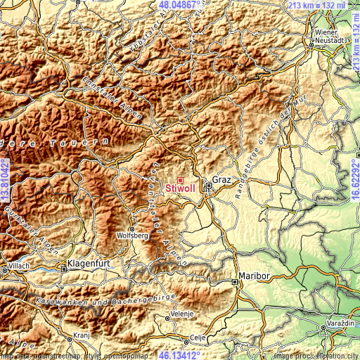
| \ | Map #1 | Topo.Map |
| Scale [m] | 403..864 m | × |
| Scale [ft] | 1322..2835 ft | × |
| Average | 570.1 m = 1870 ft | × |
| Width | 6.65 km = 4.1 mi | 212.9 km = 132.3 mi |
| Height | 6.65 km = 4.1 mi | 212.9 km = 132.3 mi |
| ↑Max Latitude | 47.129906° | 48.04867° |
| Latitude at center | 47.1° | 47.1° |
| ↓Min Latitude | 47.070077° | 46.13412° |
| ← Min Longitude | 15.172725° | 13.81042° |
| Longitude center | 15.21667° | 15.21667° |
| →Max Longitude | 15.260615° | 16.62292° |
Nearby cities:
Cities around Stiwoll sort by population:
• Voitsberg elevation 410 m
7.8 km,  217°
217°
• Bärnbach 426 m
7.4 km,  244°
244°
• Gratwein 406 m
7.8 km,  76°
76°
• Stallhofen 413 m
5.6 km,  180°
180°
• Hochtregist 672 m
6.3 km,  270°
270°
• Eisbach 463 m
4.2 km,  63°
63°
• Södingberg 457 m
3.5 km,  282°
282°
• Sankt Oswald bei Plankenwarth 538 m
4.8 km,  107°
107°
• Sankt Bartholomä 479 m
6 km,  147°
147°
• Kohlschwarz 573 m
7.8 km, 283°
• Geistthal 576 m
8.3 km,  332°
332°
• Piberegg 472 m
7.6 km, 265°
Multilingual:
 En español:
Stiwoll elevación 501 m.
 En France:
Stiwoll élévation 501 m.


Sources and notes:
- [note 1] Map square and city borders are not equal. Map elevation data is calculated only from area inside that square.
- [src 1] Elevation data from geonames database provided with same terms of usage.
- [src 2] The elevation map of Stiwoll is generated using elevation data from NASA's 3 arcsec (90m) resolution SRTM data.
- [src 3] Base (background) map © OpenStreetMap contributors tiles are generated by Geofabrik and OpenTopoMap.
Copyright & License:
This Stiwoll Elevation Map is licensed under CC BY-SA. You may reuse any part from this page, if you give a proper credit by linking to this URL:
 More info on terms of use page.