Arzberg elevation
Arzberg (Styria, Politischer Bezirk Weiz), Austria elevation is 660 meters and Arzberg elevation in feet is 2165 ft above sea level [src 1]. Arzberg is a seat of a third-order administrative division (feature code) with elevation that is 151 meters (495 ft) bigger than average city elevation in Austria.
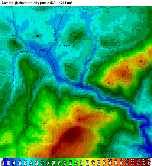
Below is the Elevation map of Arzberg, which displays elevation range with different colors. Scale of the first map is from 530 to 1211 m (1739 to 3973 ft) with average elevation of 761.8 meters (=2499 ft) [note 1]
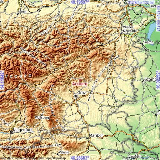
These maps also provides idea of topography and contour of this city, they are displayed at different zoom levels. More info about maps, scale and edge coordinates you can find below images.
| \ | Map #1 | Topo.Map |
| Scale [m] | 530..1211 m | × |
| Scale [ft] | 1739..3973 ft | × |
| Average | 761.8 m = 2499 ft | × |
| Width | 6.63 km = 4.1 mi | 212.3 km = 131.9 mi |
| Height | 6.63 km = 4.1 mi | 212.3 km = 131.9 mi |
| ↑Max Latitude | 47.279822° | 48.19597° |
| Latitude at center | 47.25° | 47.25° |
| ↓Min Latitude | 47.220161° | 46.28683° |
| ← Min Longitude | 15.472725° | 14.11042° |
| Longitude center | 15.51667° | 15.51667° |
| →Max Longitude | 15.560615° | 16.92292° |
Nearby cities:
Cities around Arzberg sort by population:
• Weiz elevation 506 m
8.4 km,  116°
116°
• Kumberg 517 m
9.6 km,  172°
172°
• Passail 693 m
3.7 km,  0°
0°
• Semriach 695 m
9.6 km,  247°
247°
• Göttelsberg 536 m
7.3 km, 120°
• Krottendorf 470 m
10.4 km, 122°
• Sankt Radegund bei Graz 705 m
7.8 km,  193°
193°
• Hohenau an der Raab 835 m
6.1 km,  24°
24°
• Naas 541 m
5.9 km,  89°
89°
• Stenzengreith 750 m
5.6 km,  180°
180°
• Mortantsch 486 m
6.7 km,  134°
134°
• Sankt Kathrein am Offenegg 969 m
7.5 km,  42°
42°
Multilingual:
 En español:
Arzberg elevación 660 m.
 En France:
Arzberg élévation 660 m.


Sources and notes:
- [note 1] Map square and city borders are not equal. Map elevation data is calculated only from area inside that square.
- [src 1] Elevation data from geonames database provided with same terms of usage.
- [src 2] The elevation map of Arzberg is generated using elevation data from NASA's 3 arcsec (90m) resolution SRTM data.
- [src 3] Base (background) map © OpenStreetMap contributors tiles are generated by Geofabrik and OpenTopoMap.
Copyright & License:
This Arzberg Elevation Map is licensed under CC BY-SA. You may reuse any part from this page, if you give a proper credit by linking to this URL:
 More info on terms of use page.