Grein elevation
Grein (Upper Austria, Politischer Bezirk Perg), Austria elevation is 236 meters and Grein elevation in feet is 774 ft above sea level [src 1]. Grein is a populated place (feature code) with elevation that is 273 meters (896 ft) smaller than average city elevation in Austria.
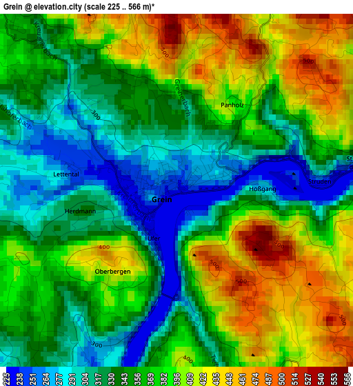
Below is the Elevation map of Grein, which displays elevation range with different colors. Scale of the first map is from 225 to 566 m (738 to 1857 ft) with average elevation of 364.6 meters (=1196 ft) [note 1]
These maps also provides idea of topography and contour of this city, they are displayed at different zoom levels. More info about maps, scale and edge coordinates you can find below images.
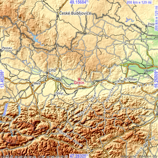
| \ | Map #1 | Topo.Map |
| Scale [m] | 225..566 m | × |
| Scale [ft] | 738..1857 ft | × |
| Average | 364.6 m = 1196 ft | × |
| Width | 6.51 km = 4 mi | 208.3 km = 129.4 mi |
| Height | 6.51 km = 4 mi | 208.3 km = 129.4 mi |
| ↑Max Latitude | 48.257886° | 49.15684° |
| Latitude at center | 48.22862° | 48.22862° |
| ↓Min Latitude | 48.199337° | 47.28325° |
| ← Min Longitude | 14.814895° | 13.45259° |
| Longitude center | 14.85884° | 14.85884° |
| →Max Longitude | 14.902785° | 16.26509° |
Nearby cities:
Cities around Grein sort by population:
• Amstetten elevation 277 m
11.8 km,  175°
175°
• Wallsee 276 m
12.6 km,  236°
236°
• Zeillern 292 m
11.6 km,  199°
199°
• Sankt Georgen am Ybbsfelde 266 m
13.1 km,  147°
147°
• Greinsfurth 280 m
13.4 km, 184°
• Ardagger Stift 332 m
8.9 km,  192°
192°
• Münzbach 415 m
11.8 km,  291°
291°
• Stephanshart 303 m
9.3 km, 199°
• Nöchling 538 m
9.1 km,  93°
93°
• Bad Kreuzen 475 m
5.8 km,  318°
318°
• Pabneukirchen 583 m
11 km,  343°
343°
• Mitterkirchen im Machland 233 m
12.9 km,  249°
249°
Multilingual:
 En español:
Grein elevación 236 m.
 En France:
Grein élévation 236 m.


Sources and notes:
- [note 1] Map square and city borders are not equal. Map elevation data is calculated only from area inside that square.
- [src 1] Elevation data from geonames database provided with same terms of usage.
- [src 2] The elevation map of Grein is generated using elevation data from NASA's 3 arcsec (90m) resolution SRTM data.
- [src 3] Base (background) map © OpenStreetMap contributors tiles are generated by Geofabrik and OpenTopoMap.
Copyright & License:
This Grein Elevation Map is licensed under CC BY-SA. You may reuse any part from this page, if you give a proper credit by linking to this URL:
 More info on terms of use page.