Nöchling elevation
Nöchling (Lower Austria, Politischer Bezirk Melk), Austria elevation is 538 meters and Nöchling elevation in feet is 1765 ft above sea level [src 1]. Nöchling is a seat of a third-order administrative division (feature code) with elevation that is 29 meters (95 ft) bigger than average city elevation in Austria.
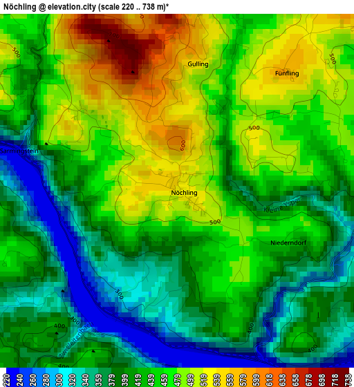
Below is the Elevation map of Nöchling, which displays elevation range with different colors. Scale of the first map is from 220 to 738 m (722 to 2421 ft) with average elevation of 434.7 meters (=1426 ft) [note 1]
These maps also provides idea of topography and contour of this city, they are displayed at different zoom levels. More info about maps, scale and edge coordinates you can find below images.
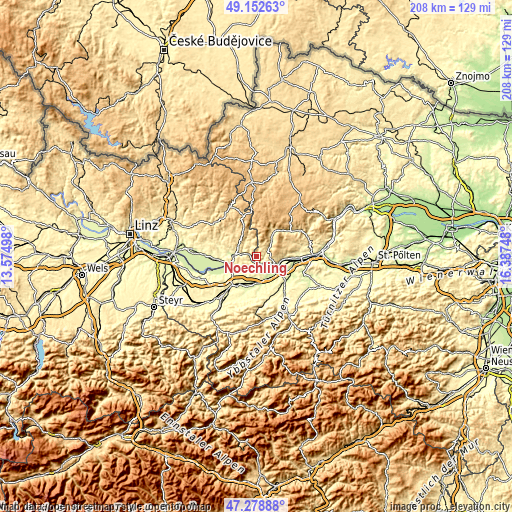
| \ | Map #1 | Topo.Map |
| Scale [m] | 220..738 m | × |
| Scale [ft] | 722..2421 ft | × |
| Average | 434.7 m = 1426 ft | × |
| Width | 6.51 km = 4 mi | 208.3 km = 129.4 mi |
| Height | 6.51 km = 4 mi | 208.3 km = 129.4 mi |
| ↑Max Latitude | 48.253599° | 49.15263° |
| Latitude at center | 48.22433° | 48.22433° |
| ↓Min Latitude | 48.195045° | 47.27888° |
| ← Min Longitude | 14.937285° | 13.57498° |
| Longitude center | 14.98123° | 14.98123° |
| →Max Longitude | 15.025175° | 16.38748° |
Nearby cities:
Cities around Nöchling sort by population:
• Ybbs an der Donau elevation 218 m
9.9 km,  130°
130°
• Blindenmarkt 246 m
10.8 km,  177°
177°
• Grein 236 m
9.1 km,  273°
273°
• Sankt Georgen am Ybbsfelde 266 m
10.8 km,  190°
190°
• Persenbeug 219 m
8.9 km,  117°
117°
• Neumarkt an der Ybbs 227 m
10.9 km,  148°
148°
• Ysper 497 m
9.3 km,  39°
39°
• Sankt Martin am Ybbsfelde 294 m
7.3 km,  156°
156°
• Hofamt Priel 271 m
7.8 km,  113°
113°
• Marbach an der Donau 256 m
12.5 km,  93°
93°
• Maria Taferl 435 m
13.2 km, 88°
• Dorfstetten 742 m
11.3 km,  0°
0°
Multilingual:
 En español:
Nöchling elevación 538 m.
 En France:
Nöchling élévation 538 m.
 Auf Deutsch:
Nöchling höhe über dem Meeresspiegel ist 538 m.

Sources and notes:
- [note 1] Map square and city borders are not equal. Map elevation data is calculated only from area inside that square.
- [src 1] Elevation data from geonames database provided with same terms of usage.
- [src 2] The elevation map of Nöchling is generated using elevation data from NASA's 3 arcsec (90m) resolution SRTM data.
- [src 3] Base (background) map © OpenStreetMap contributors tiles are generated by Geofabrik and OpenTopoMap.
Copyright & License:
This Nöchling Elevation Map is licensed under CC BY-SA. You may reuse any part from this page, if you give a proper credit by linking to this URL:
 More info on terms of use page.