Pabneukirchen elevation
Pabneukirchen (Upper Austria, Politischer Bezirk Perg), Austria elevation is 583 meters and Pabneukirchen elevation in feet is 1913 ft above sea level [src 1]. Pabneukirchen is a seat of a third-order administrative division (feature code) with elevation that is 74 meters (243 ft) bigger than average city elevation in Austria.
Below is the Elevation map of Pabneukirchen, which displays elevation range with different colors. Scale of the first map is from 408 to 832 m (1339 to 2730 ft) with average elevation of 612.6 meters (=2010 ft) [note 1]
These maps also provides idea of topography and contour of this city, they are displayed at different zoom levels. More info about maps, scale and edge coordinates you can find below images.
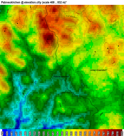
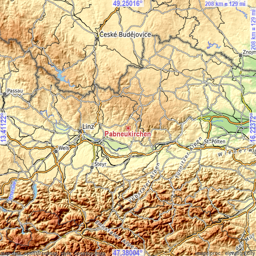
| \ | Map #1 | Topo.Map |
| Scale [m] | 408..832 m | × |
| Scale [ft] | 1339..2730 ft | × |
| Average | 612.6 m = 2010 ft | × |
| Width | 6.5 km = 4 mi | 207.9 km = 129.2 mi |
| Height | 6.5 km = 4 mi | 207.9 km = 129.2 mi |
| ↑Max Latitude | 48.352882° | 49.25016° |
| Latitude at center | 48.32367° | 48.32367° |
| ↓Min Latitude | 48.294441° | 47.38004° |
| ← Min Longitude | 14.773525° | 13.41122° |
| Longitude center | 14.81747° | 14.81747° |
| →Max Longitude | 14.861415° | 16.22372° |
Nearby cities:
Cities around Pabneukirchen sort by population:
• Perg elevation 252 m
15.9 km,  238°
238°
• Grein 236 m
11 km,  163°
163°
• Tragwein 484 m
14.5 km,  274°
274°
• Bad Zell 511 m
11.3 km,  284°
284°
• Königswiesen 568 m
9.1 km,  9°
9°
• Münzbach 415 m
10.1 km,  231°
231°
• Bad Kreuzen 475 m
6.3 km,  187°
187°
• Windhaag bei Perg 517 m
10.9 km,  247°
247°
• Allerheiligen im Mühlkreis 553 m
12.6 km,  259°
259°
• Bärnkopf 964 m
15.7 km,  61°
61°
• Pierbach 495 m
5.3 km,  300°
300°
• Dorfstetten 742 m
12.2 km,  88°
88°
Multilingual:
 En español:
Pabneukirchen elevación 583 m.
 En France:
Pabneukirchen élévation 583 m.
 Auf Deutsch:
Pabneukirchen höhe über dem Meeresspiegel ist 583 m.

Sources and notes:
- [note 1] Map square and city borders are not equal. Map elevation data is calculated only from area inside that square.
- [src 1] Elevation data from geonames database provided with same terms of usage.
- [src 2] The elevation map of Pabneukirchen is generated using elevation data from NASA's 3 arcsec (90m) resolution SRTM data.
- [src 3] Base (background) map © OpenStreetMap contributors tiles are generated by Geofabrik and OpenTopoMap.
Copyright & License:
This Pabneukirchen Elevation Map is licensed under CC BY-SA. You may reuse any part from this page, if you give a proper credit by linking to this URL:
 More info on terms of use page.