Ludmannsdorf elevation
Ludmannsdorf (Carinthia, Politischer Bezirk Klagenfurt Land), Austria elevation is 570 meters and Ludmannsdorf elevation in feet is 1870 ft above sea level [src 1]. Ludmannsdorf is a seat of a third-order administrative division (feature code) with elevation that is 61 meters (200 ft) bigger than average city elevation in Austria.
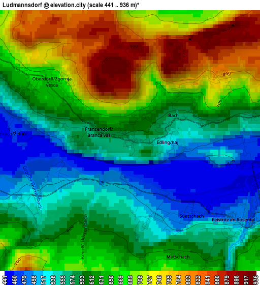
Below is the Elevation map of Ludmannsdorf, which displays elevation range with different colors. Scale of the first map is from 441 to 936 m (1447 to 3071 ft) with average elevation of 634.5 meters (=2082 ft) [note 1]
These maps also provides idea of topography and contour of this city, they are displayed at different zoom levels. More info about maps, scale and edge coordinates you can find below images.
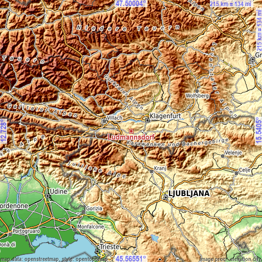
| \ | Map #1 | Topo.Map |
| Scale [m] | 441..936 m | × |
| Scale [ft] | 1447..3071 ft | × |
| Average | 634.5 m = 2082 ft | × |
| Width | 6.72 km = 4.2 mi | 215.1 km = 133.7 mi |
| Height | 6.72 km = 4.2 mi | 215.1 km = 133.7 mi |
| ↑Max Latitude | 46.571609° | 47.50004° |
| Latitude at center | 46.54139° | 46.54139° |
| ↓Min Latitude | 46.511155° | 45.56551° |
| ← Min Longitude | 14.090305° | 12.728° |
| Longitude center | 14.13425° | 14.13425° |
| →Max Longitude | 14.178195° | 15.5405° |
Nearby cities:
Cities around Ludmannsdorf sort by population:
• Viktring elevation 458 m
11.7 km,  61°
61°
• Ferlach 464 m
12.9 km,  97°
97°
• Krumpendorf 615 m
12 km,  31°
31°
• Pörtschach am Wörthersee 449 m
10.6 km,  5°
5°
• Velden am Wörthersee 448 m
10.7 km,  318°
318°
• Feistritz im Rosental 554 m
3.7 km,  137°
137°
• Maria Rain 558 m
12.4 km,  83°
83°
• Schiefling am See 567 m
7.6 km,  338°
338°
• Köttmannsdorf 542 m
7.9 km,  73°
73°
• Rosegg 480 m
10.4 km,  300°
300°
• Keutschach am See 552 m
7.1 km,  36°
36°
• Maria Wörth 442 m
8.6 km, 14°
Multilingual:
 En español:
Ludmannsdorf elevación 570 m.
 En France:
Ludmannsdorf élévation 570 m.
 Auf Deutsch:
Ludmannsdorf höhe über dem Meeresspiegel ist 570 m.

Sources and notes:
- [note 1] Map square and city borders are not equal. Map elevation data is calculated only from area inside that square.
- [src 1] Elevation data from geonames database provided with same terms of usage.
- [src 2] The elevation map of Ludmannsdorf is generated using elevation data from NASA's 3 arcsec (90m) resolution SRTM data.
- [src 3] Base (background) map © OpenStreetMap contributors tiles are generated by Geofabrik and OpenTopoMap.
Copyright & License:
This Ludmannsdorf Elevation Map is licensed under CC BY-SA. You may reuse any part from this page, if you give a proper credit by linking to this URL:
 More info on terms of use page.