Ferlach elevation
Ferlach (Carinthia, Politischer Bezirk Klagenfurt Land), Austria elevation is 464 meters and Ferlach elevation in feet is 1522 ft above sea level [src 1]. Ferlach is a seat of a third-order administrative division (feature code) with elevation that is 45 meters (148 ft) smaller than average city elevation in Austria.
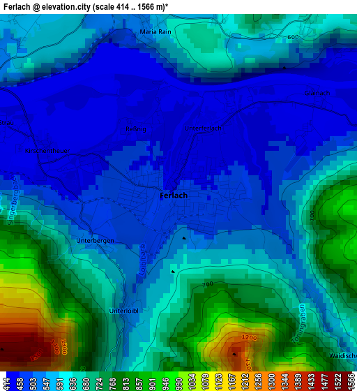
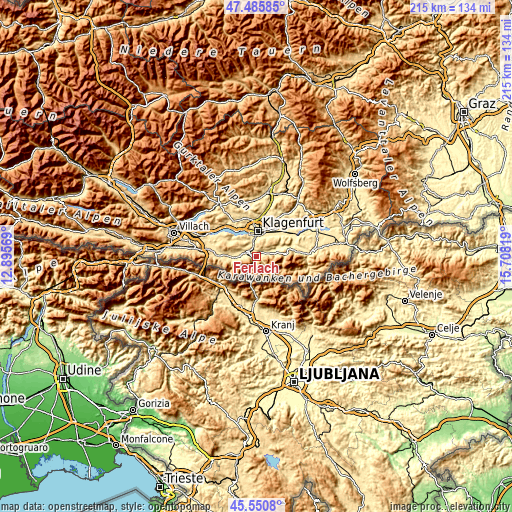
Below is the Elevation map of Ferlach, which displays elevation range with different colors. Scale of the first map is from 414 to 1566 m (1358 to 5138 ft) with average elevation of 611.7 meters (=2007 ft) [note 1]
These maps also provides idea of topography and contour of this city, they are displayed at different zoom levels. More info about maps, scale and edge coordinates you can find below images.

| \ | Map #1 | Map #2 | Topo.Map |
| Scale [m] | 414..1566 m | 408..1820 m | × |
| Scale [ft] | 1358..5138 ft | 1339..5971 ft | × |
| Average | 611.7 m = 2007 ft | 772.9 m = 2536 ft | × |
| Width | 6.72 km = 4.2 mi | 13.45 km = 8.4 mi | 215.2 km = 133.7 mi |
| Height | 6.72 km = 4.2 mi | 13.45 km = 8.4 mi | 215.1 km = 133.7 mi |
| ↑Max Latitude | 46.557167° | 46.587376° | 47.48585° |
| Latitude at center | 46.52694° | 46.52694° | 46.52694° |
| ↓Min Latitude | 46.496697° | 46.466436° | 45.5508° |
| ← Min Longitude | 14.257995° | 14.214049° | 12.89569° |
| Longitude center | 14.30194° | 14.30194° | 14.30194° |
| →Max Longitude | 14.345885° | 14.389831° | 15.70819° |
Nearby cities:
Cities around Ferlach sort by population:
• Klagenfurt am Wörthersee elevation 450 m
10.9 km,  1°
1°
• Sankt Martin 443 m
10.1 km,  351°
351°
• Viktring 458 m
7.6 km,  340°
340°
• Villacher Vorstadt 448 m
10.8 km, 354°
• Sankt Ruprecht 438 m
8.2 km,  7°
7°
• Viktringer Vorstadt 436 m
10.1 km, 3°
• Ebenthal 427 m
10.2 km,  27°
27°
• Rain 420 m
10.8 km,  36°
36°
• Feistritz im Rosental 554 m
10.4 km,  263°
263°
• Maria Rain 558 m
3 km, 350°
• Köttmannsdorf 542 m
6.5 km,  306°
306°
• Sankt Margareten im Rosental 570 m
9.6 km,  78°
78°
Multilingual:
 En español:
Ferlach elevación 464 m.
 En France:
Ferlach élévation 464 m.


Sources and notes:
- [note 1] Map square and city borders are not equal. Map elevation data is calculated only from area inside that square.
- [src 1] Elevation data from geonames database provided with same terms of usage.
- [src 2] The elevation map of Ferlach is generated using elevation data from NASA's 3 arcsec (90m) resolution SRTM data.
- [src 3] Base (background) map © OpenStreetMap contributors tiles are generated by Geofabrik and OpenTopoMap.
Copyright & License:
This Ferlach Elevation Map is licensed under CC BY-SA. You may reuse any part from this page, if you give a proper credit by linking to this URL:
 More info on terms of use page.