Krumpendorf elevation
Krumpendorf (Carinthia, Politischer Bezirk Klagenfurt Land), Austria elevation is 615 meters and Krumpendorf elevation in feet is 2018 ft above sea level [src 1]. Krumpendorf is a populated place (feature code) with elevation that is 106 meters (348 ft) bigger than average city elevation in Austria.
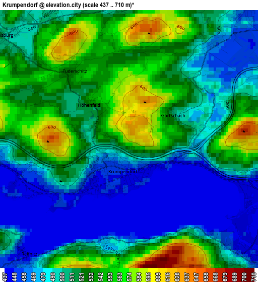
Below is the Elevation map of Krumpendorf, which displays elevation range with different colors. Scale of the first map is from 437 to 710 m (1434 to 2329 ft) with average elevation of 510.8 meters (=1676 ft) [note 1]
These maps also provides idea of topography and contour of this city, they are displayed at different zoom levels. More info about maps, scale and edge coordinates you can find below images.
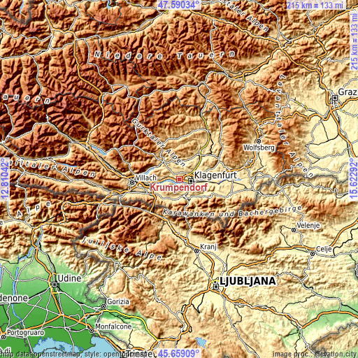
| \ | Map #1 | Topo.Map |
| Scale [m] | 437..710 m | × |
| Scale [ft] | 1434..2329 ft | × |
| Average | 510.8 m = 1676 ft | × |
| Width | 6.71 km = 4.2 mi | 214.7 km = 133.4 mi |
| Height | 6.71 km = 4.2 mi | 214.7 km = 133.4 mi |
| ↑Max Latitude | 46.663497° | 47.59034° |
| Latitude at center | 46.63333° | 46.63333° |
| ↓Min Latitude | 46.603146° | 45.65909° |
| ← Min Longitude | 14.172725° | 12.81042° |
| Longitude center | 14.21667° | 14.21667° |
| →Max Longitude | 14.260615° | 15.62292° |
Nearby cities:
Cities around Krumpendorf sort by population:
• Klagenfurt am Wörthersee elevation 450 m
6.8 km,  98°
98°
• Sankt Martin 443 m
5.4 km,  109°
109°
• Annabichl 454 m
7.9 km,  76°
76°
• Viktring 458 m
6.1 km,  138°
138°
• Villacher Vorstadt 448 m
5.6 km, 101°
• Wölfnitz 458 m
4.8 km,  40°
40°
• St. Veiter Vorstadt 446 m
6.8 km,  91°
91°
• Viktringer Vorstadt 436 m
7.3 km, 103°
• Pörtschach am Wörthersee 449 m
5.4 km,  273°
273°
• Moosburg 500 m
4.2 km,  310°
310°
• Keutschach am See 552 m
5 km,  205°
205°
• Maria Wörth 442 m
4.5 km,  245°
245°
Multilingual:
 En español:
Krumpendorf elevación 615 m.
 En France:
Krumpendorf élévation 615 m.
 Auf Deutsch:
Krumpendorf höhe über dem Meeresspiegel ist 615 m.

Sources and notes:
- [note 1] Map square and city borders are not equal. Map elevation data is calculated only from area inside that square.
- [src 1] Elevation data from geonames database provided with same terms of usage.
- [src 2] The elevation map of Krumpendorf is generated using elevation data from NASA's 3 arcsec (90m) resolution SRTM data.
- [src 3] Base (background) map © OpenStreetMap contributors tiles are generated by Geofabrik and OpenTopoMap.
Copyright & License:
This Krumpendorf Elevation Map is licensed under CC BY-SA. You may reuse any part from this page, if you give a proper credit by linking to this URL:
 More info on terms of use page.