Velden am Wörthersee elevation
Velden am Wörthersee (Carinthia, Politischer Bezirk Villach Land), Austria elevation is 448 meters and Velden am Wörthersee elevation in feet is 1470 ft above sea level [src 1]. Velden am Wörthersee is a populated place (feature code) with elevation that is 61 meters (200 ft) smaller than average city elevation in Austria.
Below is the Elevation map of Velden am Wörthersee, which displays elevation range with different colors. Scale of the first map is from 437 to 812 m (1434 to 2664 ft) with average elevation of 557.1 meters (=1828 ft) [note 1]
These maps also provides idea of topography and contour of this city, they are displayed at different zoom levels. More info about maps, scale and edge coordinates you can find below images.
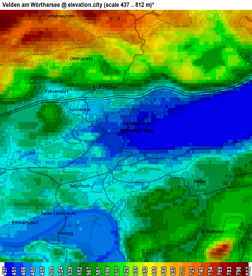
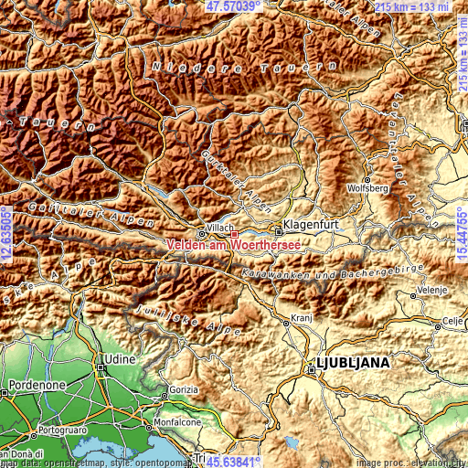
| \ | Map #1 | Topo.Map |
| Scale [m] | 437..812 m | × |
| Scale [ft] | 1434..2664 ft | × |
| Average | 557.1 m = 1828 ft | × |
| Width | 6.71 km = 4.2 mi | 214.8 km = 133.5 mi |
| Height | 6.71 km = 4.2 mi | 214.8 km = 133.5 mi |
| ↑Max Latitude | 46.643189° | 47.57039° |
| Latitude at center | 46.61301° | 46.61301° |
| ↓Min Latitude | 46.582815° | 45.63841° |
| ← Min Longitude | 13.997355° | 12.63505° |
| Longitude center | 14.0413° | 14.0413° |
| →Max Longitude | 14.085245° | 15.44755° |
Nearby cities:
Cities around Velden am Wörthersee sort by population:
• Finkenstein am Faaker See elevation 557 m
9 km,  245°
245°
• Pörtschach am Wörthersee 449 m
8.4 km,  72°
72°
• Ledenitzen 586 m
8 km,  229°
229°
• Föderlach I 467 m
6.3 km,  256°
256°
• Schiefling am See 567 m
4.4 km,  102°
102°
• Wernberg 530 m
8.3 km,  272°
272°
• Steindorf am Ossiacher See 528 m
9.8 km,  345°
345°
• Rosegg 480 m
3.3 km,  213°
213°
• Maria Wörth 442 m
9.3 km,  87°
87°
• Ossiach 516 m
8.1 km,  327°
327°
• Wudmath 500 m
5 km, 248°
• Schleben 560 m
8.3 km,  275°
275°
Multilingual:
 En español:
Velden am Wörthersee elevación 448 m.
 En France:
Velden am Wörthersee élévation 448 m.
 Auf Deutsch:
Velden, Velden am Wörthersee höhe über dem Meeresspiegel ist 448 m.
 На русском:
Фельден-ам-Вёртерзе высота над уровнем моря 448 м
Sources and notes:
- [note 1] Map square and city borders are not equal. Map elevation data is calculated only from area inside that square.
- [src 1] Elevation data from geonames database provided with same terms of usage.
- [src 2] The elevation map of Velden am Wörthersee is generated using elevation data from NASA's 3 arcsec (90m) resolution SRTM data.
- [src 3] Base (background) map © OpenStreetMap contributors tiles are generated by Geofabrik and OpenTopoMap.
Copyright & License:
This Velden am Wörthersee Elevation Map is licensed under CC BY-SA. You may reuse any part from this page, if you give a proper credit by linking to this URL:
 More info on terms of use page.