Ossiach elevation
Ossiach (Carinthia, Politischer Bezirk Feldkirchen), Austria elevation is 516 meters and Ossiach elevation in feet is 1693 ft above sea level [src 1]. Ossiach is a seat of a third-order administrative division (feature code) with elevation that is 7 meters (23 ft) bigger than average city elevation in Austria.
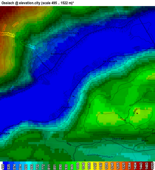
Below is the Elevation map of Ossiach, which displays elevation range with different colors. Scale of the first map is from 495 to 1522 m (1624 to 4993 ft) with average elevation of 738.5 meters (=2423 ft) [note 1]
These maps also provides idea of topography and contour of this city, they are displayed at different zoom levels. More info about maps, scale and edge coordinates you can find below images.
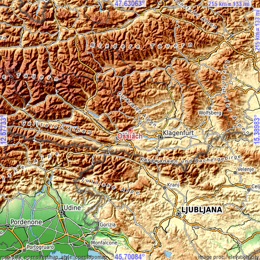
| \ | Map #1 | Topo.Map |
| Scale [m] | 495..1522 m | × |
| Scale [ft] | 1624..4993 ft | × |
| Average | 738.5 m = 2423 ft | × |
| Width | 6.71 km = 4.2 mi | 214.6 km = 133.3 mi |
| Height | 6.71 km = 4.2 mi | 214.6 km = 133.3 mi |
| ↑Max Latitude | 46.704494° | 47.63063° |
| Latitude at center | 46.67435° | 46.67435° |
| ↓Min Latitude | 46.644189° | 45.70084° |
| ← Min Longitude | 13.939635° | 12.57733° |
| Longitude center | 13.98358° | 13.98358° |
| →Max Longitude | 14.027525° | 15.38983° |
Nearby cities:
Cities around Ossiach sort by population:
• Velden am Wörthersee elevation 448 m
8.1 km,  147°
147°
• Sankt Magdalen 497 m
10 km,  230°
230°
• Bodensdorf 549 m
2.1 km,  332°
332°
• Waiern 590 m
9.7 km,  50°
50°
• Föderlach I 467 m
8.4 km,  191°
191°
• Wernberg 530 m
7.5 km,  210°
210°
• Himmelberg 697 m
9.8 km,  21°
21°
• Steindorf am Ossiacher See 528 m
3.3 km,  36°
36°
• Rosegg 480 m
9.9 km,  164°
164°
• Wudmath 500 m
8.7 km,  181°
181°
• Schleben 560 m
7.1 km, 212°
• Fresen 772 m
5.8 km, 53°
Multilingual:
 En español:
Ossiach elevación 516 m.
 En France:
Ossiach élévation 516 m.


Sources and notes:
- [note 1] Map square and city borders are not equal. Map elevation data is calculated only from area inside that square.
- [src 1] Elevation data from geonames database provided with same terms of usage.
- [src 2] The elevation map of Ossiach is generated using elevation data from NASA's 3 arcsec (90m) resolution SRTM data.
- [src 3] Base (background) map © OpenStreetMap contributors tiles are generated by Geofabrik and OpenTopoMap.
Copyright & License:
This Ossiach Elevation Map is licensed under CC BY-SA. You may reuse any part from this page, if you give a proper credit by linking to this URL:
 More info on terms of use page.