Waiern elevation
Waiern (Carinthia, Politischer Bezirk Feldkirchen), Austria elevation is 590 meters and Waiern elevation in feet is 1936 ft above sea level [src 1]. Waiern is a populated place (feature code) with elevation that is 81 meters (266 ft) bigger than average city elevation in Austria.
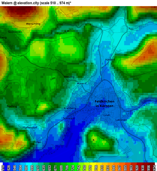
Below is the Elevation map of Waiern, which displays elevation range with different colors. Scale of the first map is from 510 to 974 m (1673 to 3196 ft) with average elevation of 650.6 meters (=2135 ft) [note 1]
These maps also provides idea of topography and contour of this city, they are displayed at different zoom levels. More info about maps, scale and edge coordinates you can find below images.
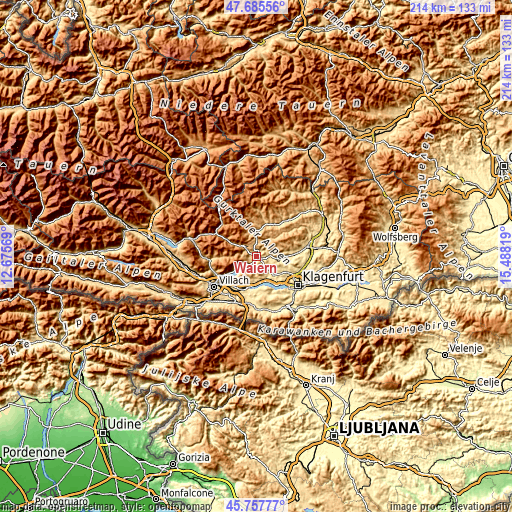
| \ | Map #1 | Topo.Map |
| Scale [m] | 510..974 m | × |
| Scale [ft] | 1673..3196 ft | × |
| Average | 650.6 m = 2135 ft | × |
| Width | 6.7 km = 4.2 mi | 214.4 km = 133.2 mi |
| Height | 6.7 km = 4.2 mi | 214.3 km = 133.2 mi |
| ↑Max Latitude | 46.760393° | 47.68556° |
| Latitude at center | 46.73028° | 46.73028° |
| ↓Min Latitude | 46.70015° | 45.75777° |
| ← Min Longitude | 14.037995° | 12.67569° |
| Longitude center | 14.08194° | 14.08194° |
| →Max Longitude | 14.125885° | 15.48819° |
Nearby cities:
Cities around Waiern sort by population:
• Feldkirchen in Kärnten elevation 543 m
1.3 km,  124°
124°
• Bodensdorf 549 m
9.5 km,  242°
242°
• Himmelberg 697 m
4.9 km,  306°
306°
• Steindorf am Ossiacher See 528 m
6.6 km, 237°
• Gnesau 973 m
10.4 km,  298°
298°
• Glanegg 529 m
9 km,  95°
95°
• Steuerberg 796 m
6.8 km,  20°
20°
• Ossiach 516 m
9.7 km,  230°
230°
• Seitenberg 641 m
2 km,  13°
13°
• Mautbrücken 501 m
8.6 km, 97°
• Draschen 792 m
4.5 km,  345°
345°
• Fresen 772 m
4 km, 225°
Multilingual:
 En español:
Waiern elevación 590 m.
 En France:
Waiern élévation 590 m.


Sources and notes:
- [note 1] Map square and city borders are not equal. Map elevation data is calculated only from area inside that square.
- [src 1] Elevation data from geonames database provided with same terms of usage.
- [src 2] The elevation map of Waiern is generated using elevation data from NASA's 3 arcsec (90m) resolution SRTM data.
- [src 3] Base (background) map © OpenStreetMap contributors tiles are generated by Geofabrik and OpenTopoMap.
Copyright & License:
This Waiern Elevation Map is licensed under CC BY-SA. You may reuse any part from this page, if you give a proper credit by linking to this URL:
 More info on terms of use page.