Pettneu elevation
Pettneu (Tyrol, Politischer Bezirk Landeck), Austria elevation is 1193 meters and Pettneu elevation in feet is 3914 ft above sea level [src 1]. Pettneu is a populated place (feature code) with elevation that is 684 meters (2244 ft) bigger than average city elevation in Austria.
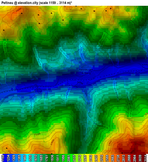
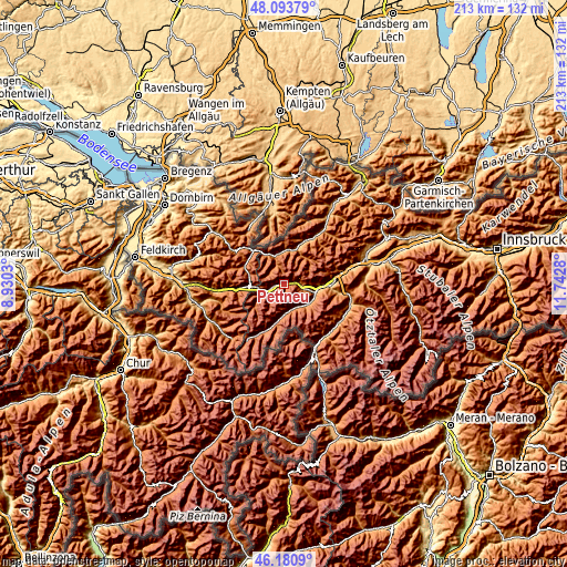
Below is the Elevation map of Pettneu, which displays elevation range with different colors. Scale of the first map is from 1159 to 3114 m (3802 to 10217 ft) with average elevation of 1845.4 meters (=6054 ft) [note 1]
These maps also provides idea of topography and contour of this city, they are displayed at different zoom levels. More info about maps, scale and edge coordinates you can find below images.
| \ | Map #1 | Topo.Map |
| Scale [m] | 1159..3114 m | × |
| Scale [ft] | 3802..10217 ft | × |
| Average | 1845.4 m = 6054 ft | × |
| Width | 6.65 km = 4.1 mi | 212.7 km = 132.2 mi |
| Height | 6.65 km = 4.1 mi | 212.7 km = 132.2 mi |
| ↑Max Latitude | 47.17583° | 48.09379° |
| Latitude at center | 47.14595° | 47.14595° |
| ↓Min Latitude | 47.116053° | 46.1809° |
| ← Min Longitude | 10.292605° | 8.9303° |
| Longitude center | 10.33655° | 10.33655° |
| →Max Longitude | 10.380495° | 11.7428° |
Nearby cities:
Cities around Pettneu sort by population:
• Kappl elevation 1321 m
9.5 km,  158°
158°
• St Anton am Arlberg 1307 m
5.9 km,  249°
249°
• Lech 1442 m
16.3 km,  295°
295°
• Grins 996 m
13.4 km,  92°
92°
• See 1036 m
12.1 km,  125°
125°
• Ischgl 1378 m
15.2 km,  192°
192°
• Strengen 1011 m
9.7 km,  103°
103°
• Flirsch 1176 m
4.8 km,  84°
84°
• Pians 848 m
13.4 km, 95°
• Tobadill 1163 m
13.6 km, 99°
• Holzgau 1104 m
12.7 km,  2°
2°
• Steeg 1116 m
11.4 km,  343°
343°
Multilingual:
 En español:
Pettneu elevación 1193 m.
 En France:
Pettneu élévation 1193 m.
 Auf Deutsch:
Pettneu höhe über dem Meeresspiegel ist 1193 m.

Sources and notes:
- [note 1] Map square and city borders are not equal. Map elevation data is calculated only from area inside that square.
- [src 1] Elevation data from geonames database provided with same terms of usage.
- [src 2] The elevation map of Pettneu is generated using elevation data from NASA's 3 arcsec (90m) resolution SRTM data.
- [src 3] Base (background) map © OpenStreetMap contributors tiles are generated by Geofabrik and OpenTopoMap.
Copyright & License:
This Pettneu Elevation Map is licensed under CC BY-SA. You may reuse any part from this page, if you give a proper credit by linking to this URL:
 More info on terms of use page.