Pians elevation
Pians (Tyrol, Politischer Bezirk Landeck), Austria elevation is 848 meters and Pians elevation in feet is 2782 ft above sea level [src 1]. Pians is a seat of a third-order administrative division (feature code) with elevation that is 339 meters (1112 ft) bigger than average city elevation in Austria.
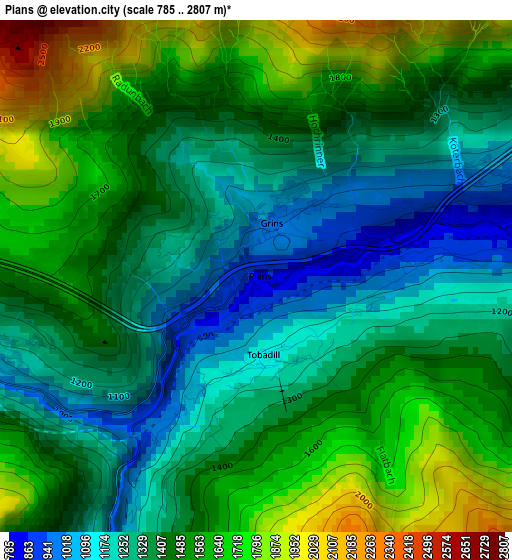
Below is the Elevation map of Pians, which displays elevation range with different colors. Scale of the first map is from 785 to 2807 m (2575 to 9209 ft) with average elevation of 1438.3 meters (=4719 ft) [note 1]
These maps also provides idea of topography and contour of this city, they are displayed at different zoom levels. More info about maps, scale and edge coordinates you can find below images.
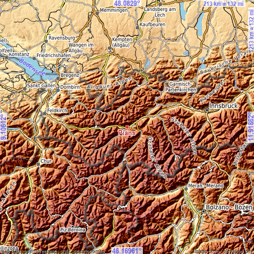
| \ | Map #1 | Topo.Map |
| Scale [m] | 785..2807 m | × |
| Scale [ft] | 2575..9209 ft | × |
| Average | 1438.3 m = 4719 ft | × |
| Width | 6.65 km = 4.1 mi | 212.7 km = 132.2 mi |
| Height | 6.65 km = 4.1 mi | 212.7 km = 132.2 mi |
| ↑Max Latitude | 47.164746° | 48.0829° |
| Latitude at center | 47.13486° | 47.13486° |
| ↓Min Latitude | 47.104957° | 46.16961° |
| ← Min Longitude | 10.468425° | 9.10612° |
| Longitude center | 10.51237° | 10.51237° |
| →Max Longitude | 10.556315° | 11.91862° |
Nearby cities:
Cities around Pians sort by population:
• Landeck elevation 789 m
4.1 km,  82°
82°
• Zams 770 m
6.4 km,  65°
65°
• Fliess 835 m
8.1 km,  104°
104°
• Kappl 1321 m
12.4 km,  232°
232°
• Grins 996 m
0.6 km,  12°
12°
• See 1036 m
6.7 km,  211°
211°
• Strengen 1011 m
3.9 km,  255°
255°
• Fiss 1464 m
11.7 km,  137°
137°
• Flirsch 1176 m
8.7 km,  281°
281°
• Stanz bei Landeck 1025 m
3.4 km, 65°
• Ladis 1193 m
12.4 km,  122°
122°
• Tobadill 1163 m
1.1 km,  173°
173°
Multilingual:
 En español:
Pians elevación 848 m.
 En France:
Pians élévation 848 m.


Sources and notes:
- [note 1] Map square and city borders are not equal. Map elevation data is calculated only from area inside that square.
- [src 1] Elevation data from geonames database provided with same terms of usage.
- [src 2] The elevation map of Pians is generated using elevation data from NASA's 3 arcsec (90m) resolution SRTM data.
- [src 3] Base (background) map © OpenStreetMap contributors tiles are generated by Geofabrik and OpenTopoMap.
Copyright & License:
This Pians Elevation Map is licensed under CC BY-SA. You may reuse any part from this page, if you give a proper credit by linking to this URL:
 More info on terms of use page.