Lech elevation
Lech (Vorarlberg, Politischer Bezirk Bludenz), Austria elevation is 1442 meters and Lech elevation in feet is 4731 ft above sea level [src 1]. Lech is a seat of a third-order administrative division (feature code) with elevation that is 933 meters (3061 ft) bigger than average city elevation in Austria.
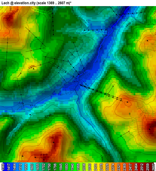
Below is the Elevation map of Lech, which displays elevation range with different colors. Scale of the first map is from 1369 to 2607 m (4491 to 8553 ft) with average elevation of 1856.7 meters (=6092 ft) [note 1]
These maps also provides idea of topography and contour of this city, they are displayed at different zoom levels. More info about maps, scale and edge coordinates you can find below images.
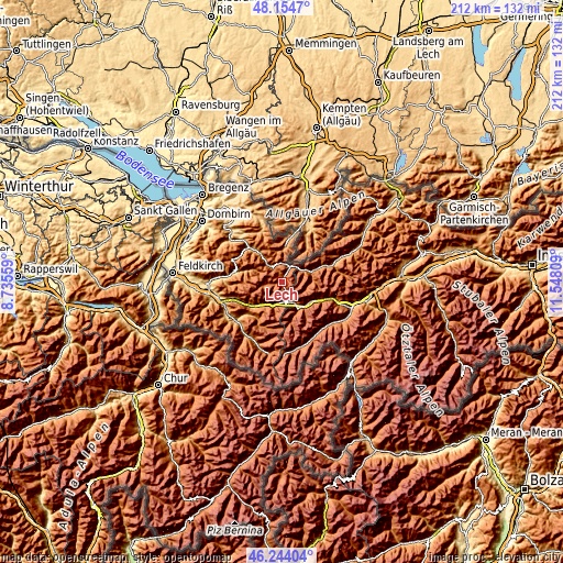
| \ | Map #1 | Topo.Map |
| Scale [m] | 1369..2607 m | × |
| Scale [ft] | 4491..8553 ft | × |
| Average | 1856.7 m = 6092 ft | × |
| Width | 6.64 km = 4.1 mi | 212.4 km = 132 mi |
| Height | 6.64 km = 4.1 mi | 212.4 km = 132 mi |
| ↑Max Latitude | 47.237815° | 48.1547° |
| Latitude at center | 47.20797° | 47.20797° |
| ↓Min Latitude | 47.178108° | 46.24404° |
| ← Min Longitude | 10.097895° | 8.73559° |
| Longitude center | 10.14184° | 10.14184° |
| →Max Longitude | 10.185785° | 11.54809° |
Nearby cities:
Cities around Lech sort by population:
• Riezlern elevation 1092 m
17 km,  11°
11°
• St Anton am Arlberg 1307 m
12.8 km,  134°
134°
• Mittelberg 1142 m
16.1 km, 8°
• Hirschegg 1104 m
15.7 km, 8°
• Pettneu 1193 m
16.3 km,  115°
115°
• Dalaas 873 m
14.7 km,  230°
230°
• Schoppernau 839 m
14.9 km,  320°
320°
• Klösterle 1124 m
9.4 km,  208°
208°
• Holzgau 1104 m
16.4 km,  69°
69°
• Steeg 1116 m
12.2 km, 70°
• Schröcken 1265 m
6.7 km,  325°
325°
• Warth 1332 m
5.6 km,  33°
33°
Multilingual:
 En español:
Lech elevación 1442 m.
 En France:
Lech élévation 1442 m.


Sources and notes:
- [note 1] Map square and city borders are not equal. Map elevation data is calculated only from area inside that square.
- [src 1] Elevation data from geonames database provided with same terms of usage.
- [src 2] The elevation map of Lech is generated using elevation data from NASA's 3 arcsec (90m) resolution SRTM data.
- [src 3] Base (background) map © OpenStreetMap contributors tiles are generated by Geofabrik and OpenTopoMap.
Copyright & License:
This Lech Elevation Map is licensed under CC BY-SA. You may reuse any part from this page, if you give a proper credit by linking to this URL:
 More info on terms of use page.