St Anton am Arlberg elevation
St Anton am Arlberg (Tyrol, Politischer Bezirk Landeck), Austria elevation is 1307 meters and St Anton am Arlberg elevation in feet is 4288 ft above sea level [src 1]. St Anton am Arlberg is a populated place (feature code) with elevation that is 798 meters (2618 ft) bigger than average city elevation in Austria.
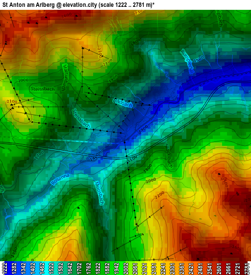
Below is the Elevation map of St Anton am Arlberg, which displays elevation range with different colors. Scale of the first map is from 1222 to 2781 m (4009 to 9124 ft) with average elevation of 1877.5 meters (=6160 ft) [note 1]
These maps also provides idea of topography and contour of this city, they are displayed at different zoom levels. More info about maps, scale and edge coordinates you can find below images.
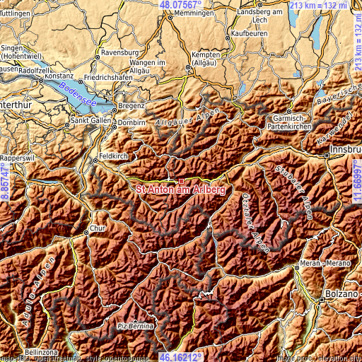
| \ | Map #1 | Topo.Map |
| Scale [m] | 1222..2781 m | × |
| Scale [ft] | 4009..9124 ft | × |
| Average | 1877.5 m = 6160 ft | × |
| Width | 6.65 km = 4.1 mi | 212.8 km = 132.2 mi |
| Height | 6.65 km = 4.1 mi | 212.8 km = 132.2 mi |
| ↑Max Latitude | 47.157391° | 48.07567° |
| Latitude at center | 47.1275° | 47.1275° |
| ↓Min Latitude | 47.097593° | 46.16212° |
| ← Min Longitude | 10.219775° | 8.85747° |
| Longitude center | 10.26372° | 10.26372° |
| →Max Longitude | 10.307665° | 11.66997° |
Nearby cities:
Cities around St Anton am Arlberg sort by population:
• Kappl elevation 1321 m
11.3 km,  126°
126°
• Lech 1442 m
12.8 km,  314°
314°
• See 1036 m
16.1 km,  107°
107°
• Ischgl 1378 m
13 km,  170°
170°
• Strengen 1011 m
15 km,  90°
90°
• Pettneu 1193 m
5.9 km,  69°
69°
• Flirsch 1176 m
10.6 km,  76°
76°
• Pians 848 m
18.8 km, 87°
• Klösterle 1124 m
13.7 km,  272°
272°
• Holzgau 1104 m
16 km,  22°
22°
• Steeg 1116 m
13.2 km,  10°
10°
• Warth 1332 m
14.9 km,  335°
335°
Multilingual:
 En español:
St Anton am Arlberg elevación 1307 m.
 En France:
St Anton am Arlberg élévation 1307 m.
 Auf Deutsch:
St. Anton am Arlberg höhe über dem Meeresspiegel ist 1307 m.
 На русском:
Санкт-Антон-ам-Арльберг высота над уровнем моря 1307 м
Sources and notes:
- [note 1] Map square and city borders are not equal. Map elevation data is calculated only from area inside that square.
- [src 1] Elevation data from geonames database provided with same terms of usage.
- [src 2] The elevation map of St Anton am Arlberg is generated using elevation data from NASA's 3 arcsec (90m) resolution SRTM data.
- [src 3] Base (background) map © OpenStreetMap contributors tiles are generated by Geofabrik and OpenTopoMap.
Copyright & License:
This St Anton am Arlberg Elevation Map is licensed under CC BY-SA. You may reuse any part from this page, if you give a proper credit by linking to this URL:
 More info on terms of use page.