Unterwaltersdorf elevation
Unterwaltersdorf (Lower Austria, Politischer Bezirk Baden), Austria elevation is 198 meters and Unterwaltersdorf elevation in feet is 650 ft above sea level [src 1]. Unterwaltersdorf is a populated place (feature code) with elevation that is 311 meters (1020 ft) smaller than average city elevation in Austria.
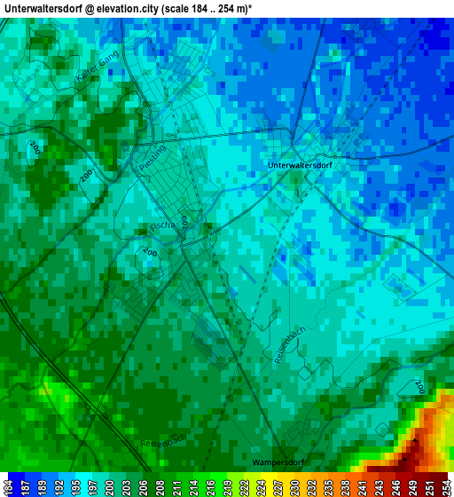
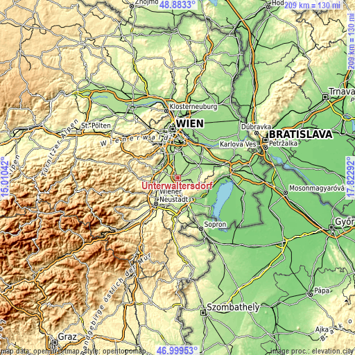
Below is the Elevation map of Unterwaltersdorf, which displays elevation range with different colors. Scale of the first map is from 184 to 254 m (604 to 833 ft) with average elevation of 200.1 meters (=656 ft) [note 1]
These maps also provides idea of topography and contour of this city, they are displayed at different zoom levels. More info about maps, scale and edge coordinates you can find below images.
| \ | Map #1 | Topo.Map |
| Scale [m] | 184..254 m | × |
| Scale [ft] | 604..833 ft | × |
| Average | 200.1 m = 656 ft | × |
| Width | 6.55 km = 4.1 mi | 209.5 km = 130.2 mi |
| Height | 6.55 km = 4.1 mi | 209.4 km = 130.1 mi |
| ↑Max Latitude | 47.979425° | 48.8833° |
| Latitude at center | 47.95° | 47.95° |
| ↓Min Latitude | 47.920558° | 46.99953° |
| ← Min Longitude | 16.372725° | 15.01042° |
| Longitude center | 16.41667° | 16.41667° |
| →Max Longitude | 16.460615° | 17.82292° |
Nearby cities:
Cities around Unterwaltersdorf sort by population:
• Ebreichsdorf elevation 199 m
1 km,  311°
311°
• Oberwaltersdorf 212 m
7.6 km,  292°
292°
• Pottendorf 219 m
6.1 km,  204°
204°
• Trumau 201 m
7.3 km, 311°
• Hornstein 269 m
8 km,  164°
164°
• Mitterndorf an der Fischa 187 m
6.8 km,  38°
38°
• Weigelsdorf 202 m
1.2 km,  270°
270°
• Moosbrunn 183 m
7.8 km,  18°
18°
• Wimpassing an der Leitha 207 m
3.9 km, 161°
• Leithaprodersdorf 194 m
5 km,  111°
111°
• Landegg 216 m
5.7 km,  192°
192°
• Seibersdorf 184 m
7.6 km,  82°
82°
Multilingual:
 En español:
Unterwaltersdorf elevación 198 m.
 En France:
Unterwaltersdorf élévation 198 m.
 Auf Deutsch:
Unterwaltersdorf höhe über dem Meeresspiegel ist 198 m.

Sources and notes:
- [note 1] Map square and city borders are not equal. Map elevation data is calculated only from area inside that square.
- [src 1] Elevation data from geonames database provided with same terms of usage.
- [src 2] The elevation map of Unterwaltersdorf is generated using elevation data from NASA's 3 arcsec (90m) resolution SRTM data.
- [src 3] Base (background) map © OpenStreetMap contributors tiles are generated by Geofabrik and OpenTopoMap.
Copyright & License:
This Unterwaltersdorf Elevation Map is licensed under CC BY-SA. You may reuse any part from this page, if you give a proper credit by linking to this URL:
 More info on terms of use page.