Hornstein elevation
Hornstein (Burgenland, Eisenstadt-Umgebung), Austria elevation is 269 meters and Hornstein elevation in feet is 883 ft above sea level [src 1]. Hornstein is a seat of a third-order administrative division (feature code) with elevation that is 240 meters (787 ft) smaller than average city elevation in Austria.
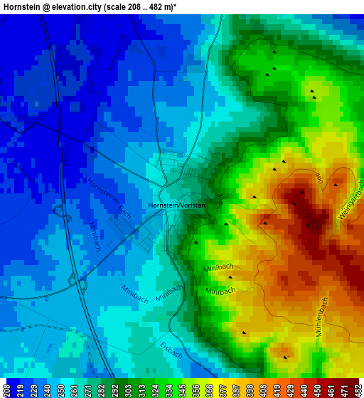
Below is the Elevation map of Hornstein, which displays elevation range with different colors. Scale of the first map is from 208 to 482 m (682 to 1581 ft) with average elevation of 288.5 meters (=947 ft) [note 1]
These maps also provides idea of topography and contour of this city, they are displayed at different zoom levels. More info about maps, scale and edge coordinates you can find below images.
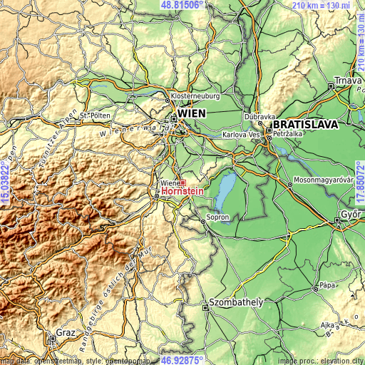
| \ | Map #1 | Topo.Map |
| Scale [m] | 208..482 m | × |
| Scale [ft] | 682..1581 ft | × |
| Average | 288.5 m = 947 ft | × |
| Width | 6.55 km = 4.1 mi | 209.7 km = 130.3 mi |
| Height | 6.55 km = 4.1 mi | 209.7 km = 130.3 mi |
| ↑Max Latitude | 47.909955° | 48.81506° |
| Latitude at center | 47.88049° | 47.88049° |
| ↓Min Latitude | 47.851008° | 46.92875° |
| ← Min Longitude | 16.400525° | 15.03822° |
| Longitude center | 16.44447° | 16.44447° |
| →Max Longitude | 16.488415° | 17.85072° |
Nearby cities:
Cities around Hornstein sort by population:
• Eisenstadt elevation 182 m
7 km,  123°
123°
• Pottendorf 219 m
5 km,  295°
295°
• Neufeld an der Leitha 231 m
5.2 km,  251°
251°
• Kleinhöflein im Burgenland 212 m
6.2 km,  134°
134°
• Steinbrunn 211 m
5.6 km,  201°
201°
• Ebenfurth 228 m
5.8 km,  266°
266°
• Grosshöflein 212 m
5.6 km,  151°
151°
• Wimpassing an der Leitha 207 m
4.1 km,  348°
348°
• Müllendorf 233 m
4.8 km,  163°
163°
• Leithaprodersdorf 194 m
6.4 km,  23°
23°
• Landegg 216 m
4 km, 303°
• Loretto 211 m
6.7 km,  54°
54°
Multilingual:
 En español:
Hornstein elevación 269 m.
 En France:
Hornstein élévation 269 m.
 Auf Deutsch:
Hornstein höhe über dem Meeresspiegel ist 269 m.

Sources and notes:
- [note 1] Map square and city borders are not equal. Map elevation data is calculated only from area inside that square.
- [src 1] Elevation data from geonames database provided with same terms of usage.
- [src 2] The elevation map of Hornstein is generated using elevation data from NASA's 3 arcsec (90m) resolution SRTM data.
- [src 3] Base (background) map © OpenStreetMap contributors tiles are generated by Geofabrik and OpenTopoMap.
Copyright & License:
This Hornstein Elevation Map is licensed under CC BY-SA. You may reuse any part from this page, if you give a proper credit by linking to this URL:
 More info on terms of use page.