Limay Mahuida elevation
Limay Mahuida (La Pampa, Departamento de Limay Mahuida), Argentina elevation is 265 meters and Limay Mahuida elevation in feet is 869 ft above sea level [src 1]. Limay Mahuida is a seat of a second-order administrative division (feature code) with elevation that is 85 meters (279 ft) smaller than average city elevation in Argentina.
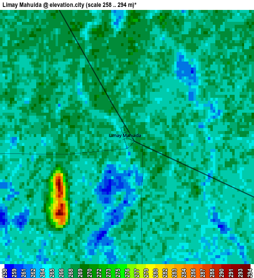
Below is the Elevation map of Limay Mahuida, which displays elevation range with different colors. Scale of the first map is from 258 to 294 m (846 to 965 ft) with average elevation of 266.5 meters (=874 ft) [note 1]
These maps also provides idea of topography and contour of this city, they are displayed at different zoom levels. More info about maps, scale and edge coordinates you can find below images.
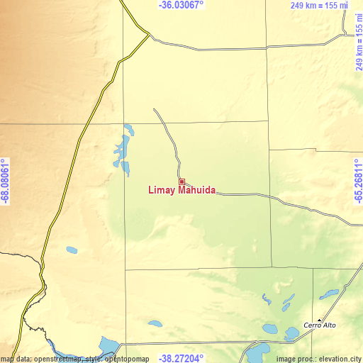
| \ | Map #1 | Topo.Map |
| Scale [m] | 258..294 m | × |
| Scale [ft] | 846..965 ft | × |
| Average | 266.5 m = 874 ft | × |
| Width | 7.79 km = 4.8 mi | 249.2 km = 154.8 mi |
| Height | 7.79 km = 4.8 mi | 249.2 km = 154.8 mi |
| ↑Max Latitude | -37.124629° | -36.03067° |
| Latitude at center | -37.15966° | -37.15966° |
| ↓Min Latitude | -37.194674° | -38.27204° |
| ← Min Longitude | -66.718305° | -68.08061° |
| Longitude center | -66.67436° | -66.67436° |
| →Max Longitude | -66.630415° | -65.26811° |
Nearby cities:
Cities around Limay Mahuida sort by population:
• Catriel elevation 323 m
127.2 km,  231°
231°
• General Acha 230 m
184.8 km,  97°
97°
• Veinticinco de Mayo 348 m
114.6 km, 233°
• Victorica 314 m
152.4 km,  46°
46°
• General Enrique Godoy 209 m
217.6 km,  191°
191°
• Contraalmirante Cordero 303 m
217 km,  216°
216°
• Santa Isabel 315 m
106.4 km,  347°
347°
• Telén 303 m
143.8 km, 46°
• Toay 190 m
211.1 km,  75°
75°
• Rincón de Los Sauces 608 m
201.2 km,  262°
262°
• Puelches 235 m
128.4 km,  148°
148°
• Algarrobo del Águila 306 m
94.3 km,  333°
333°
Multilingual:
 En español:
Limay Mahuida elevación 265 m.
 En France:
Limay Mahuida élévation 265 m.
 Auf Deutsch:
Limay Mahuida höhe über dem Meeresspiegel ist 265 m.

Sources and notes:
- [note 1] Map square and city borders are not equal. Map elevation data is calculated only from area inside that square.
- [src 1] Elevation data from geonames database provided with same terms of usage.
- [src 2] The elevation map of Limay Mahuida is generated using elevation data from NASA's 3 arcsec (90m) resolution SRTM data.
- [src 3] Base (background) map © OpenStreetMap contributors tiles are generated by Geofabrik and OpenTopoMap.
Copyright & License:
This Limay Mahuida Elevation Map is licensed under CC BY-SA. You may reuse any part from this page, if you give a proper credit by linking to this URL:
 More info on terms of use page.