Santa Isabel elevation
Santa Isabel (La Pampa, Departamento de Chalileo), Argentina elevation is 315 meters and Santa Isabel elevation in feet is 1033 ft above sea level [src 1]. Santa Isabel is a seat of a second-order administrative division (feature code) with elevation that is 35 meters (115 ft) smaller than average city elevation in Argentina.
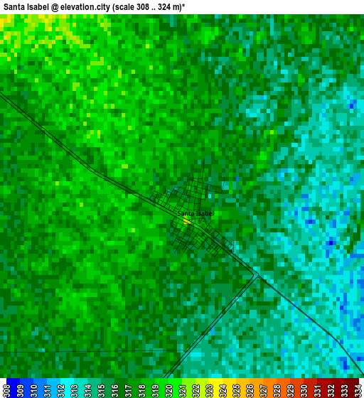
Below is the Elevation map of Santa Isabel, which displays elevation range with different colors. Scale of the first map is from 308 to 324 m (1010 to 1063 ft) with average elevation of 316.1 meters (=1037 ft) [note 1]
These maps also provides idea of topography and contour of this city, they are displayed at different zoom levels. More info about maps, scale and edge coordinates you can find below images.
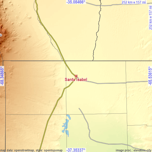
| \ | Map #1 | Topo.Map |
| Scale [m] | 308..324 m | × |
| Scale [ft] | 1010..1063 ft | × |
| Average | 316.1 m = 1037 ft | × |
| Width | 7.88 km = 4.9 mi | 252.3 km = 156.8 mi |
| Height | 7.88 km = 4.9 mi | 252.3 km = 156.8 mi |
| ↑Max Latitude | -36.191782° | -35.08466° |
| Latitude at center | -36.22724° | -36.22724° |
| ↓Min Latitude | -36.262682° | -37.35337° |
| ← Min Longitude | -66.986345° | -68.34865° |
| Longitude center | -66.9424° | -66.9424° |
| →Max Longitude | -66.898455° | -65.53615° |
Nearby cities:
Cities around Santa Isabel sort by population:
• San Rafael elevation 702 m
218.7 km,  324°
324°
• Catriel 323 m
198.7 km,  202°
202°
• Veinticinco de Mayo 348 m
185.2 km, 201°
• Victorica 314 m
135.1 km,  89°
89°
• Buena Esperanza 323 m
223.9 km,  43°
43°
• Unión 378 m
149.6 km, 36°
• Telén 303 m
128.5 km, 91°
• La Maruja 283 m
190.5 km,  71°
71°
• Rincón de Los Sauces 608 m
219.6 km,  233°
233°
• General Alvear 478 m
154.6 km,  334°
334°
• Limay Mahuida 265 m
106.4 km,  167°
167°
• Algarrobo del Águila 306 m
26.4 km,  223°
223°
Multilingual:
 En español:
Santa Isabel elevación 315 m.
 En France:
Santa Isabel élévation 315 m.
 Auf Deutsch:
Santa Isabel höhe über dem Meeresspiegel ist 315 m.

Sources and notes:
- [note 1] Map square and city borders are not equal. Map elevation data is calculated only from area inside that square.
- [src 1] Elevation data from geonames database provided with same terms of usage.
- [src 2] The elevation map of Santa Isabel is generated using elevation data from NASA's 3 arcsec (90m) resolution SRTM data.
- [src 3] Base (background) map © OpenStreetMap contributors tiles are generated by Geofabrik and OpenTopoMap.
Copyright & License:
This Santa Isabel Elevation Map is licensed under CC BY-SA. You may reuse any part from this page, if you give a proper credit by linking to this URL:
 More info on terms of use page.