San Rafael elevation
San Rafael (Mendoza, Departamento de San Rafael), Argentina elevation is 702 meters and San Rafael elevation in feet is 2303 ft above sea level [src 1]. San Rafael is a seat of a second-order administrative division (feature code) with elevation that is 352 meters (1155 ft) bigger than average city elevation in Argentina.
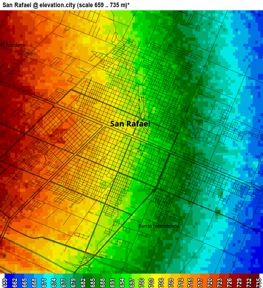
Below is the Elevation map of San Rafael, which displays elevation range with different colors. Scale of the first map is from 659 to 735 m (2162 to 2411 ft) with average elevation of 696.2 meters (=2284 ft) [note 1]
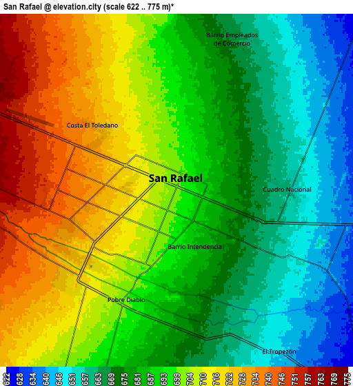
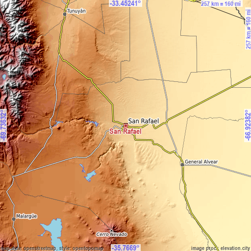
These maps also provides idea of topography and contour of this city, they are displayed at different zoom levels. More info about maps, scale and edge coordinates you can find below images.
| \ | Map #1 | Map #2 | Topo.Map |
| Scale [m] | 659..735 m | 622..775 m | × |
| Scale [ft] | 2162..2411 ft | 2041..2543 ft | × |
| Average | 696.2 m = 2284 ft | 691.1 m = 2267 ft | × |
| Width | 8.04 km = 5 mi | 16.08 km = 10 mi | 257.3 km = 159.9 mi |
| Height | 8.04 km = 5 mi | 16.08 km = 10 mi | 257.3 km = 159.9 mi |
| ↑Max Latitude | -34.581547° | -34.545358° | -33.45241° |
| Latitude at center | -34.61772° | -34.61772° | -34.61772° |
| ↓Min Latitude | -34.653877° | -34.690019° | -35.7669° |
| ← Min Longitude | -68.374015° | -68.417961° | -69.73632° |
| Longitude center | -68.33007° | -68.33007° | -68.33007° |
| →Max Longitude | -68.286125° | -68.242179° | -66.92382° |
Nearby cities:
Cities around San Rafael sort by population:
• San Martín elevation 661 m
171.3 km,  355°
355°
• Maipú 813 m
186.9 km,  347°
347°
• Luján de Cuyo 955 m
183.1 km,  343°
343°
• Junín 669 m
164 km, 355°
• Rivadavia 667 m
159.1 km, 355°
• Tupungato 1077 m
157.8 km,  331°
331°
• Santa Rosa 610 m
152.5 km,  6°
6°
• Malargüe 1421 m
148.8 km,  230°
230°
• La Paz 510 m
147.4 km,  29°
29°
• Tunuyán 883 m
131.8 km, 331°
• La Consulta 1025 m
122.1 km,  323°
323°
• General Alvear 478 m
70.7 km,  124°
124°
Multilingual:
 En español:
San Rafael elevación 702 m.
 En France:
San Rafael élévation 702 m.
 Auf Deutsch:
San Rafael höhe über dem Meeresspiegel ist 702 m.

Sources and notes:
- [note 1] Map square and city borders are not equal. Map elevation data is calculated only from area inside that square.
- [src 1] Elevation data from geonames database provided with same terms of usage.
- [src 2] The elevation map of San Rafael is generated using elevation data from NASA's 3 arcsec (90m) resolution SRTM data.
- [src 3] Base (background) map © OpenStreetMap contributors tiles are generated by Geofabrik and OpenTopoMap.
Copyright & License:
This San Rafael Elevation Map is licensed under CC BY-SA. You may reuse any part from this page, if you give a proper credit by linking to this URL:
 More info on terms of use page.