Malargüe elevation
Malargüe (Mendoza, Departamento de Malargüe), Argentina elevation is 1421 meters and Malargüe elevation in feet is 4662 ft above sea level [src 1]. Malargüe is a seat of a second-order administrative division (feature code) with elevation that is 1071 meters (3514 ft) bigger than average city elevation in Argentina.
Below is the Elevation map of Malargüe, which displays elevation range with different colors. Scale of the first map is from 1385 to 1523 m (4544 to 4997 ft) with average elevation of 1423.9 meters (=4672 ft) [note 1]
These maps also provides idea of topography and contour of this city, they are displayed at different zoom levels. More info about maps, scale and edge coordinates you can find below images.
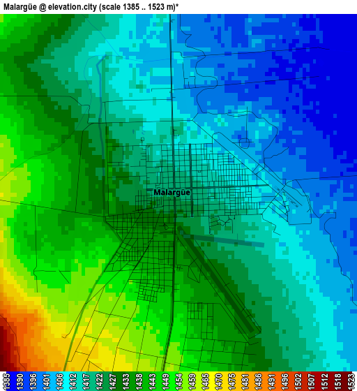
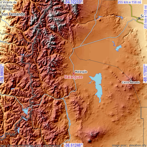
| \ | Map #1 | Topo.Map |
| Scale [m] | 1385..1523 m | × |
| Scale [ft] | 4544..4997 ft | × |
| Average | 1423.9 m = 4672 ft | × |
| Width | 7.96 km = 4.9 mi | 254.7 km = 158.3 mi |
| Height | 7.96 km = 4.9 mi | 254.7 km = 158.3 mi |
| ↑Max Latitude | -35.439655° | -34.32213° |
| Latitude at center | -35.47545° | -35.47545° |
| ↓Min Latitude | -35.51123° | -36.61246° |
| ← Min Longitude | -69.628215° | -70.99052° |
| Longitude center | -69.58427° | -69.58427° |
| →Max Longitude | -69.540325° | -68.17802° |
Nearby cities:
Cities around Malargüe sort by population:
• San Rafael elevation 702 m
148.8 km,  50°
50°
• Chos Malal 858 m
220.3 km,  196°
196°
• Andacollo 1096 m
212.9 km,  207°
207°
• Buta Ranquil 1152 m
177.3 km,  188°
188°
• Las Ovejas 1264 m
198.1 km, 211°
• Barrancas 1099 m
152.8 km, 191°
• Algarrobo del Águila 306 m
242.4 km,  115°
115°
• Tupungato 1077 m
237.3 km,  9°
9°
• Rincón de Los Sauces 608 m
221.7 km,  164°
164°
• Tunuyán 883 m
217.5 km, 13°
• La Consulta 1025 m
198 km, 12°
• General Alvear 478 m
180.7 km,  72°
72°
Multilingual:
 En español:
Malargüe elevación 1421 m.
 En France:
Malargüe élévation 1421 m.
 Auf Deutsch:
Malargüe höhe über dem Meeresspiegel ist 1421 m.

Sources and notes:
- [note 1] Map square and city borders are not equal. Map elevation data is calculated only from area inside that square.
- [src 1] Elevation data from geonames database provided with same terms of usage.
- [src 2] The elevation map of Malargüe is generated using elevation data from NASA's 3 arcsec (90m) resolution SRTM data.
- [src 3] Base (background) map © OpenStreetMap contributors tiles are generated by Geofabrik and OpenTopoMap.
Copyright & License:
This Malargüe Elevation Map is licensed under CC BY-SA. You may reuse any part from this page, if you give a proper credit by linking to this URL:
 More info on terms of use page.